A One Place Study brings together aspects of family history, local history and even house history. They are often carried out by family historians looking to learn more about their ancestors. A One Place Study might add new records, broaden out the focus or just bring a new perspective to our research.
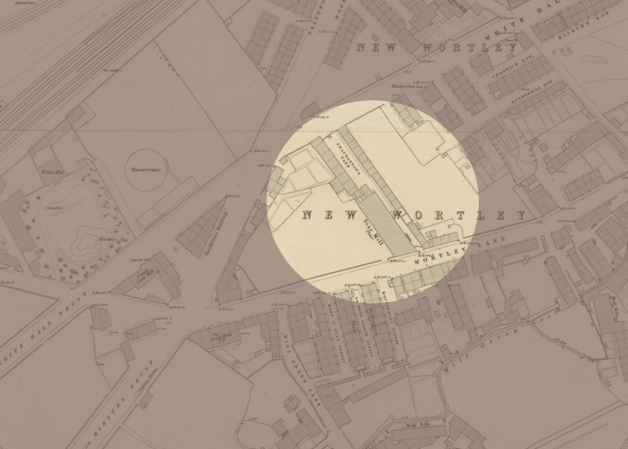
Shackleton’s Fold was a small ‘street’ of just nineteen houses that stood in the New Wortley area of Leeds for more than ninety years. It was demolished by the end of the 1930s. In the video linked below I use maps and old photos to try to explore the area where it once stood.
I found this process so useful in helping me to imagine what Shackleton’s Fold was like. Poring over old maps and finding photographs of buildings all around the Fold – alas none of Shackleton’s Fold itself – really helped me to focus.
I hope this video will be of interest to family historians, local historians and people doing or thinking of doing a One Place Study. In addition, people with a general interest in Leeds history, specifically the history of New Wortley may find it interesting.
I’m particularly keen to attract other family historians whose research has taken them back to Shackleton’s Fold between the mid 1840s and 1938. Alongside this visual exploration, I’m in the process of creating a database of every person on the censuses and every voter listed on the electoral registers. I’m looking for stories and photographs and would be very grateful if anyone could help out in that regard. I’ve already found some interesting stories.
If you fall into any of these categories, or know someone who does, please do share a link to this post and/or the YouTube link – and please ‘Like’ the video if you have a YouTube account. I hope you’ll find it useful.
Information and Links for photos and maps used
All photographs from Leodis: https://Leodis.net Go to Advanced search and key in the ID given.
JR Holmes and Star Maltings on Wortley Road, 1965. ID: 2003729_72382754
Star Maltings and Shackleton’s Fold on Wortley Road, 1965. ID: 2003729_99482364
View from St John’s Street to side view of Star Maltings and former Shackleton’s Fold, 1965. ID: 2003729_88186282
107-109 Whitehall Road, with view of St John’s Street, 1965. ID: 2003729_31147402
Whitehall Road School and Kildare Terrace, 1948. ID: 5624
Whitehall Road School, 1948. ID: 2818
Whitehall Road at the junction with Gelderd Road, Trolley and Tram Junction, undated but possibly 1911. ID: 2011127_173010
St John’s Sunday School (bombed 24th/25th August 1940). ID: 200828_166072
St John’s Street, from L to R: 11 to 15, 1965. ID: 2003729_52465457
Tithe apportionment of Wortley (township in the parish of Leeds) 1846. The National Archives, Kew. Reference: IR 29/43/444
Ordnance Survey Maps located at National Library of Scotland Maps: https://maps.nls.uk Reproduced with the permission of the National Library of Scotland
Ordnance Survey: Leeds Sheet 13: Surveyed: 1847. Published: 1850. Reproduced with the permission of the National Library of Scotland https://maps.nls.uk/view/229947003
The last post I published in my ‘Ancestral Tourism’ series focused on preparing for visiting former ancestral homes and business premises that are still standing. I said I would cover trying to locate buildings no longer in existence in a future post.
In this video linked below I provide two examples from my own family history of using maps, censuses, technology and sheer determination to work out where a property used to be. The first example is in Birmingham’s Deritend and Bordesley; the second is Shackleton’s Fold. If you have ‘disappeared’ houses in your ancestry, I hope you’ll find it helpful.
Please do ‘like’ it if you have a YouTube account. You could even ‘Subscribe’ to the channel if you want. It’s free. 🙂
As far as the Shackleton’s Fold theme is concerned, there will be at least two follow-on videos (currently in preparation). The first of these will use maps and old photos to focus on the area where it stood. In the second I turn detective and try to gather as many clues as possible about what Shackleton’s Fold looked like.
If you have ancestry in Shackleton’s Fold, New Wortley, Leeds (1840s-c.1938) and have an interesting family story about it, or a photograph of the street, I would love to hear from you. If you don’t have ancestry there but have access to a photograph of the street, again, please do contact me.
*****
The maps used in this video came from the National Libraries of Scotland Maps website, and as part of their permission to use I’m required to provide a link to each of the maps. Although I did put this information at the end of the video, these were not usable as hyperlinks to the original map online. I therefore provide all map information and links below.
Borough of Birmingham by J. Pigott-Smith: Sheet 190, Published: 1855 Public Domain (Wikimedia Commons) This map is also available at the National Library of Scotland: https://maps.nls.uk/view/260803014
Side by Side Map: Google Maps, 2025: Part of New Wortley, Leeds
The following maps are reproduced with the permission of the National Library of Scotland:
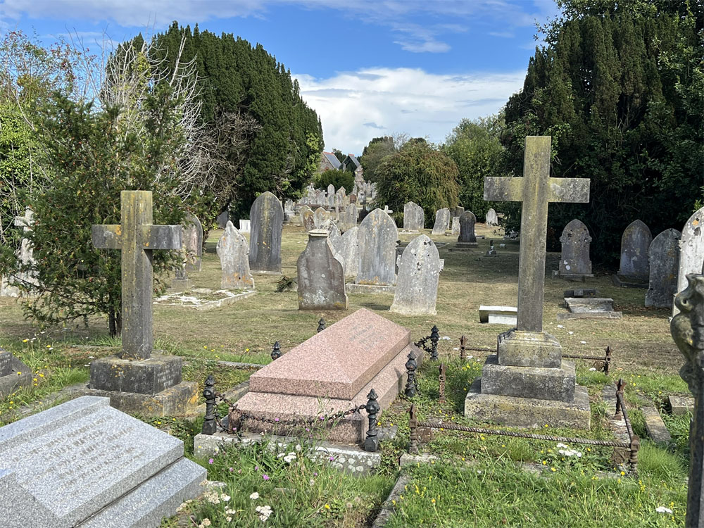
This follows on from my last post: Ancestral Tourism 1: Churches and Churchyards. It focuses on locating and visiting graves of our ancestors whose final resting place is in one of the large municipal or other public cemeteries in our towns and cities rather than in a church graveyard.
First, a bit of history
The emergence of large public cemeteries is an interesting part of our social history, connecting with several other developments of the nineteenth century that will be familiar to local and family historians. The migrations and population booms of the eighteenth and nineteenth centuries created not only a lack of housing for the living but also of burial grounds for the dead – and all the more so in the growing industrial towns and cities. The historic churchyard burial grounds posed problems on several fronts: they were generally small, overcrowded, often laid out in a haphazard manner; and as knowledge of hygiene and sanitation developed, there were concerns about the spread of disease, particularly since in towns and cities these small burial grounds were generally alongside the church and surrounded by closely packed housing.
The initial response to this problem was to turn to the private sector. Throughout the 1820s and 1830s a number of ‘garden cemeteries’ were established to serve big industrial towns, including Manchester, Liverpool, Birmingham, Leeds, Sheffield, Newcastle and later, London. These cemeteries were private commercial ventures set up under individual Acts of Parliament. They were large, well-planned spaces, often designed by the same architects and landscape designers who created public parks. Some of these garden cemeteries may be well-known to us. They include Highgate in London, Undercliffe in Bradford and Arnos Vale in Bristol.
Some of the early cemeteries were developed by and for Nonconformists. As outlined in my last post, the general practice was for Nonconformists to be buried in the parish churchyard and the service officiated by the Anglican vicar. Many prominent philanthropic capitalists were Nonconformists, and by this time were able to use their wealth and influence to bring about changes including, here, the freedom to bury their dead and conduct services according to their own beliefs and traditions. Well-known Nonconformist cemeteries include Chorlton Row Cemetery in Manchester, which opened in 1821, Low Hill Cemetery in Liverpool, opened 1825, and Woodhouse Cemetery in Leeds, 1835. It is interesting to note that it was around the same time that the State removed control of recording births (or rather baptisms), marriages and deaths (or rather burials) from the Church of England and placed that responsibility with a new General Register Office: the introduction of Civil BMDs in 1837.
Generally speaking, though, these cemeteries were money-making enterprises, serving the upper and middle classes. There was no increase in provision for the labouring classes. The response from some local authorities was to develop more cemeteries but funded by public money. Early examples are St Bartholomew’s Cemetery in Exeter, which opened in 1837, Beckett Street and Hunslet Cemeteries in Leeds, both opened 1845, and Southampton Old Cemetery, 1846. This was the beginning of the Municipal Cemeteries – publicly funded, and owned/ managed by the local corporation.
The Metropolitan Burial Act of 1852, and other Acts of Parliament that followed, empowered local authorities to establish public cemeteries and close previous overcrowded burial grounds. The new cemeteries would have uniform hygiene standards and procedures for burial, would cater for all social levels, including some lower cost options for decent burials, and would offer burial options with dedicated areas for people of all religious affiliations. Half of any new cemetery was to remain unconsecrated, allowing for burials without the Church of England service. Later, in 1879, the The Public Health (Interments) Act made it a duty of local health authorities to provide cemeteries if local conditions required it.
Historic England have produced a List of Registered Cemeteries, arranged in date order. Information is provided for each, including design, designer, whether private or municipal, and important or interesting features.
There is also a nationwide map published by the Institute of Cemetery and Crematorium Management which includes every cemetery and crematorium in the land. I’ve checked out all the ones I know and they are all present and correct.
Since there is a similarity in records of these different types of public cemetery, the following notes about how to plan for your visit is intended to cover all of them. There are in any case differences from one cemetery to another, regardless of how they came into being.
Planning your visit
Allow plenty of time for this – there is a lot of research and planning to do!
Locating the records
Needless to say, the first thing you need is to know the cemetery in which your ancestor is buried. We’ll start by looking at who holds the records, moving on to which of them might be online.
Since Municipal Cemeteries are managed by the local authority, it is they who hold the records for these cemeteries. Often, this team is known as ‘Cemeteries and Crematoria’, or ‘Cems and Crems’ for short. You can find them online by using either of these phrases as search terms and adding the name of your town or city of interest.
Some local authorities offer a look-up service. For example, Leeds Cems and Crems provide a list of all cemeteries, together with opening date. They require the name of the deceased, the date of burial and the cemetery, and will ‘check the records and if the information is correct […] let you know the grave number and section or where in the grounds the cremated remains were strewn.’ Some Cems and Crems teams charge for this service; others do not.
Some local authorities have databases available online so you can check for yourself. For example, Birmingham Cems and Crems have separate online searchable databases for each of their twelve cemeteries.
Privately owned cemeteries keep their own records. Information can be accessed via their websites. For example, at the time of writing, Highgate Cemetery charges £40 for a search. However, they also state that copies of all their records are free to consult at Camden Local Studies and Archives Centre.
That said, digital images of the records of some cemeteries are available online. You might find records from your cemetery of interest on your genealogy subscription website; or try looking on FamilySearch. From the home page navigate to Search > Images > insert the name of your place of interest and then select the appropriate era from the drop-down list. From here, you will have to scroll through to see if the records you need are included, and if they are, you will need to browse through the images of the records. Knowing the death date or at least month of death will speed things up. I found all the records from York’s Fulford Cemetery on here – and they are excellent!
Transcripts of the records of your cemetery of interest may have been included on FindAGrave (free to use). I have found on there most of my ancestors and their families who were buried in a municipal cemetery, but it is primarily run by volunteers so is inevitably a work in progress.
There is also DeceasedOnline, which helps burial authorities and crematoria to convert their register records, maps and photographs into digital form and bring them together into a central searchable collection. There is a fee to see the individual records, and I have not used this website, but it is there as an option should you wish to use it.
Locating a Map of the Cemetery
The cemetery records will hold certain essential information about your ancestor: name, address, date of burial, occupation. There may be more information, but this little lot will enable you to identify the person and be sure it’s your ancestor. There will be one other very important piece of information: the number of the grave or plot where your ancestor is buried.
Armed with this, what you need now is a map. And on this point it’s a question of digging about online. Here are some places to look:
A lot of the cemeteries have ‘Friends’, and these often have a website with maps. Examples: Friends of Beckett Street Cemetery have an astonishingly good series of online tools to help you locate and navigate your way to your ancestor’s plot. These include locations of plots, numbers and names of occupants in each, whether there is a monument or gravestone, and whether this has been photographed. A different approach is taken at Friends of Southampton Old Cemetery. They provide assistance in locating graves and request a small donation towards their conservation work. Some ‘Friends’ groups have even carried out research into the lives of those buried in the cemetery.
Local history or heritage groups may have websites with maps. One the best set of static maps I have found to date is for Ryde Cemetery by Ryde Social Heritage Group. Every plot is shown with the names of the occupants.
The local Family History Society may have mapped the cemetery. Example: Isle of Wight.
There may be a site map at the cemetery itself, but you will need to know this in advance to avoid disappointment.
Going alone or with a companion In the course of researching this post I have located every one of my ancestors and all of their children buried in Municipal and Public Cemeteries. Armed with this information, including details of family plots, plus a better understanding of the significance of each of the cemeteries, I feel sufficiently well-informed to be able to make a decision as to whether to inflict a visit to any of them on my nearest, dearest, yet genealogically disinterested. Based on this, I consider one cemetery in Leeds with a single family plot of interest to be acceptable, and another in York with just three relevant family plots. The rest have far too many plots that I would need to visit; and although one – Beckett Street Cemetery in Leeds – may be acceptable on grounds of social history, I simply couldn’t put anyone else through the monotony of locating and visiting the number of graves. Definitely, these will have to be solitary trips for me.
Part of the problem leading to this decision is that although the nineteenth century cemeteries were intended as public landscapes, and are of great historic and heritage value, lack of funding means that many of them have now become neglected. It is here that ‘Friends of’ the individual cemeteries provide a valuable service, carrying out conservation and environmental work and delivering ecological benefits – but not every cemetery has a Friends group, and some are less active than others.
You might find that the ‘Friends of’ your cemetery of interest provide tours from time to time. It might be possible to arrange your visit to coincide with that, then stay on afterwards to visit your family’s graves. Interesting for you and they will appreciate the income.
If you can’t go
There is so much information to be found online. By doing the research outlined above, making full use of online material and even, where possible, via the ‘Friends of’ website, FindAGrave or a Facebook page, requesting a photo. You can also search online for images of the cemetery. Adding “wikimedia commons” to your search term will return a selection of images that are free to use provided you credit the photographer.
Be forewarned though that the inscription on images is not always legible. This could be because of sunlight conditions on the day, severe weathering over time, or possibly just because of the quality of the image when reduced for web use. The following wonderfully clear image is from FindAGrave, but some of the images of my family’s gravestones cannot be read at all.
I hope this has given you some ideas for how to plan for a visit to a Municipal or Public Cemetery. Researching it has certainly focused my mind and I’ve found it fascinating. So fascinating, in fact, that I will be slotting in an extra couple of posts about cemeteries before progressing to finding about former homes and business premises of our ancestors in the post after that. 🙂
At the end of June/ beginning of July I spent a week in the Yorkshire Dales. We were based in Starbotton in Upper Wharfedale, which is the location of one of my two One-Place Studies. Although this was a holiday, not a research trip, we managed to fit in several places of importance in my family history, and I went off most early evenings for a walk around Starbotton.
I meant to write something about how it felt to be in this village I’ve spent so many hours thinking about, and how just being there moved on my understanding of the place. Then, one evening as I wandered around, I realised that sense of connection and immediacy would best be communicated through a short video.
What started out as one woman with very little by way of plan standing on a hill above a village and talking into a phone while recording a static scene… eventually turned into downloading video editing software, inserting additional images, creating intro and outro pages and finally launching a YouTube channel. The sound is a bit dodgy in places – it was windy and my phone doesn’t have one of those big fluffy microphone covers! – so I had to learn how to do subtitles too. I also made the mistake of recording in profile, but hopefully the extra images will compensate for that.
You don’t need a YouTube account to watch, but if you do, please give me a ‘Like’. I enjoyed the process very much and suspect there will be another video, so if you’re feeling kind and you have a YouTube account you might also like to ‘Subscribe’ to my channel – it’s all free of charge of course; it just means I’ll show up in your list if I publish something else.
Any constructive feedback would be much appreciated, particularly if you know about bitspeeds, frames per second and the like. Ideally, I need someone to tell me what settings I need to use for my exact phone model when I ‘produce’ the final version as an MP4. But that aside, here it is. I’m pleased with it, and hope you like it too. 🙂