In search of Shackleton’s Fold (and other lost places)

Ordnance Survey: Leeds Sheet 13: Surveyed: 1847. Published: 1850.
Reproduced with the permission of the National Library of Scotland
https://maps.nls.uk/view/229947003 

The last post I published in my ‘Ancestral Tourism’ series focused on preparing for visiting former ancestral homes and business premises that are still standing. I said I would cover trying to locate buildings no longer in existence in a future post.

This is that future post. It finishes my Ancestral Tourism theme, and also forms part of my One Place Study on Shackleton’s Fold.

In this video linked below I provide two examples from my own family history of using maps, censuses, technology and sheer determination to work out where a property used to be. The first example is in Birmingham’s Deritend and Bordesley; the second is Shackleton’s Fold. If you have ‘disappeared’ houses in your ancestry, I hope you’ll find it helpful.

Please do ‘like’ it if you have a YouTube account. You could even ‘Subscribe’ to the channel if you want. It’s free. 🙂

As far as the Shackleton’s Fold theme is concerned, there will be at least two follow-on videos (currently in preparation). The first of these will use maps and old photos to focus on the area where it stood. In the second I turn detective and try to gather as many clues as possible about what Shackleton’s Fold looked like.

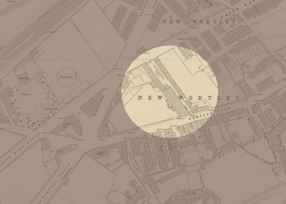
If you have ancestry in Shackleton’s Fold, New Wortley, Leeds (1840s-c.1938) and have an interesting family story about it, or a photograph of the street, I would love to hear from you. If you don’t have ancestry there but have access to a photograph of the street, again, please do contact me.

*****

The maps used in this video came from the National Libraries of Scotland Maps website, and as part of their permission to use I’m required to provide a link to each of the maps. Although I did put this information at the end of the video, these were not usable as hyperlinks to the original map online. I therefore provide all map information and links below.

Borough of Birmingham by J. Pigott-Smith: Sheet 190, Published: 1855
Public Domain (Wikimedia Commons)
This map is also available at the National Library of Scotland:
https://maps.nls.uk/view/260803014

Side by Side Map:  Google Maps, 2025:
Part of New Wortley, Leeds

The following maps are reproduced with the permission of the National Library of Scotland:

OS: Leeds Sheet 13
Surveyed: 1847,  Published: 1850. (Railway revision to c.1862)
https://maps.nls.uk/view/229947003

OS: OS 25-inch England and Wales: Yorkshire CCXVIII.5
Surveyed: 1888 to 1890, Published: 1893
https://maps.nls.uk/view/125642446

All About That Place

Advertising image for All About That Place, featuring the words 'Join All About That Place, a unique challenge event #OnePlace'

Today is Day 2 of All About That Place. I’m sure at least some of you will already know about it, and have been watching videos. I hope you’re enjoying it as much as I am. For everyone else… this is time sensitive information!

All About That Place is a ten-day event to celebrate the 10th Anniversary of the Society for One-Place Studies. It has been developed through collaboration between the Society of Genealogists, the Society for One-Place Studies, Genealogy Stories, and the British Association for Local History. However, other organisations are sponsoring specific days.

The event is being run via a pop-up Facebook Group and YouTube channel. I couldn’t find a pop-up YouTube channel specific to the event but was guided via a request for information on Facebook towards the Society of Genealogists channel. However you access the videos, they last approximately ten minutes each, and a new one appears every hour of every day, between 8am and 7pm British Summer Time. However, the time is not critical, since each video will remain online until 1st October, after which some will disappear but others will remain a little longer – only until later in October though… which is why I said this is time sensitive. By late October this post will be obsolete…

There are over a hundred pre-recorded talks to watch. They are free. My plan was to watch only the ones that interested me, but so far almost all of them have done so. I didn’t expect this to be as brilliant as it is! Clearly a great deal of work has gone into organising it.

The talks so far have looked at maps, including some great websites where mapping resources are available – some of which I’m sure you’ll already know, but others will be new to you. There have also been introductions to the kinds of resources specific organisations hold, and how they can help you in your research, like the Society of Genealogists. Some videos are about specific One-Place Studies.

As this is all about the Society for One-Place Studies, what they really want is for you to be fired up and start your own Study. They are reporting a good few new registrations already, so from that perspective this has already been a success. However, the enthusiasm amongst people participating, hosting or like me just watching is tremendous. Although all these origanisations are in the UK, people are watching from other parts of the world, and some of the One-Place Studies are in other parts of the world too.

Do give it a go!