
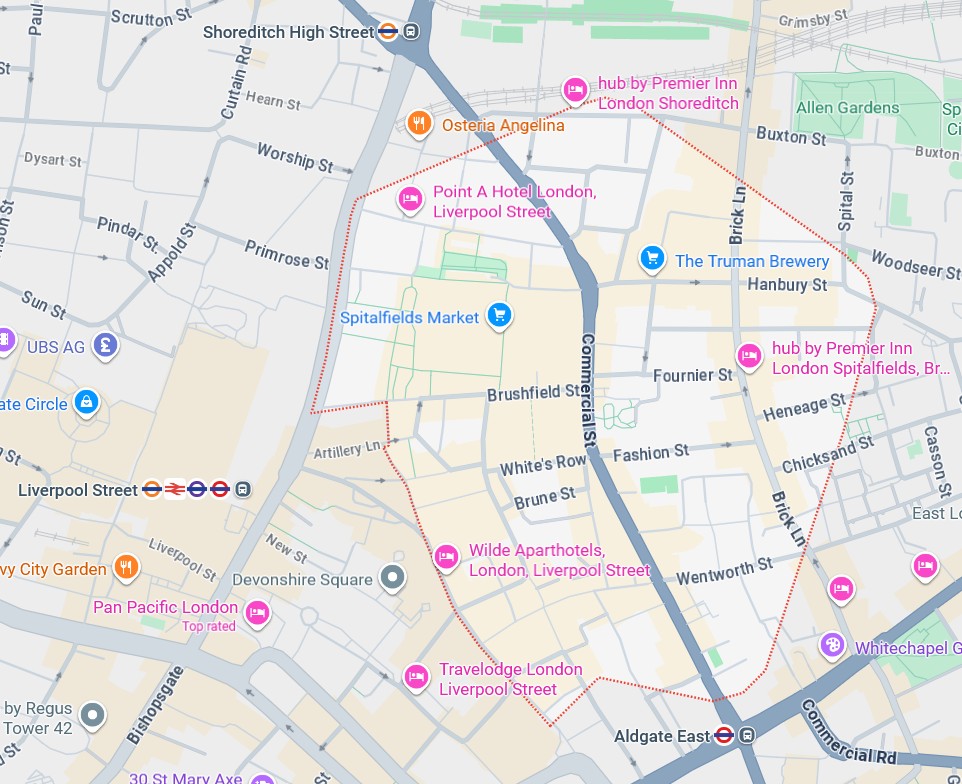
Spitalfields lies just to the north-east of the the financial centre of the City of London. In the map below, it’s the area outlined with the dotted red line: east of Liverpool Street Station, south of Shoreditch and north of Aldgate East tube stations. It forms part of the western border of the London Borough of Tower Hamlets, and it was while working in that area many years ago that I first heard of Spitalfields. I didn’t know back then, but Spitalfields has an absolutely fascinating history. It is only in the intervening years that this has gradually revealed itself to me. This post is the result of some research into the area over the last few weeks as I tried, finally, to make sense of the snippets of information I had gleaned over the years.
It’s a long read. You might want to get coffee!
What I wanted to know and understand
Spitalfields is the place where many Huguenots settled when they fled persecution in France, most intensively following the Revocation of the Edict of Nantes in 1685. When I first heard about them I assumed that migrants fleeing persecution would be in poverty. That was not necessarily the case. The Huguenots were French Protestants who, amongst other skills, excelled as silk weavers. I knew they were connected to streets of fine Georgian houses, but I didn’t know where those Georgian houses were.
This also connected to some of my own ancestors who were silk weavers in Norwich, where an earlier wave of Flemish Dissenters had settled in the sixteenth century, followed by Huguenots in the seventeenth. It seems unlikely that my ancestors were Huguenot or Flemish Dissenters. They were more likely journeymen, providing finished cloth to the merchants.
After the Huguenots, Spitalfields became home to more waves of migrants: Irish, Jewish and then, from the mid twentieth century, the British Bangladeshi community. I’ve researched a number of Jewish families in and around Brick Lane at the turn of the twentieth century, and had been a fairly regular visitor to the curry houses in Brick Lane when I worked in the area, but couldn’t make sense of the geography of the place, and where the Georgian houses were in relation to the parts I knew.
Then a few years ago, when researching an ancestral line for a client, I found a successful broker living in Spitalfields from 1729-1760. It didn’t fit with my understanding of the East End of London as a place to get a foothold in society, and I was intrigued.
I love the history of the old City of London: the hidden places, the old buildings and little alleyways, the ancient parishes and Liberties. And so, a few weeks ago, having a whole day to spare during a trip to London, we decided to spend it exploring Spitalfields. Before setting off, I researched online what there was to see. Some of the websites I used are linked at the end of this post.
I also found Dan Cruickshank’s fantastic book: Spitalfields: The history of a nation in a handful of streets (2016). It is aptly named, drawing in so much more than simply the area known as Spitalfields. Indeed, as Cruickshank writes, ‘Virtually everything of significance that happened in London in the centuries after 1530 had a profound influence upon life and architecture in Spitalfields – in some cases, indeed, these epoch-making events had their origin in the area.’ Although I bought the book specifically to learn more about Spitalfields, it has also helped me to join some dots regarding one of my own ancestral families who lived in the area to the south of Spitalfields: Whitechapel and St Katherine’s Docks. If this part of London interests you and you enjoy a long, in-depth read, I heartily recommend this book.
*****
The history of Spitalfields before the arrival of the Huguenots
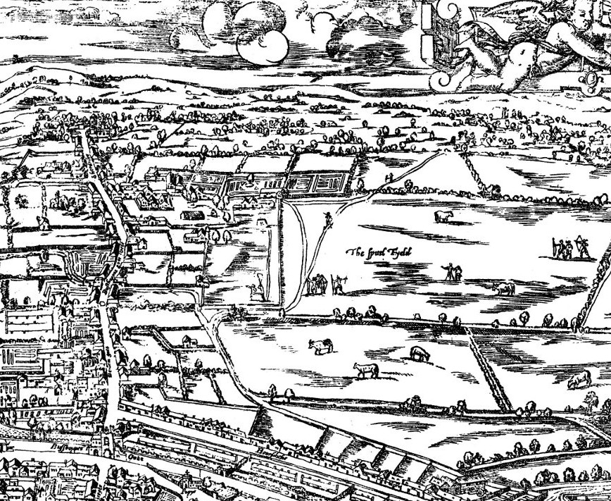
Being outside the walls of the City of London was, for centuries, emblematic of not being fully accepted within. The name ‘Spitalfields’ refers to the Hospital (‘Spital’) of the Augustinian Priory of St Mary that had stood on the spot since 1197, providing care for the sick, the dying, and for women in childbirth and their babies. Clearly, it would be considered safer to keep sick people outside the crowded area within the walls. The Spital Fields were literally the fields around and belonging to the Priory. You can see them on the map reproduced from an original by Ralph Agas, c.1560. The cluster of buildings immediately to the left (west) of the Spitel Fyeld on the map, and the laid-out gardens, are the remaining Priory buildings, by this time destroyed or used as dwelling houses. The long road running north-south to the west of the map is Bishopsgate, and the lower part of the map is the north-eastern edge of the City of London.
Cruickshank writes of Spitalfields as historically a sort of ‘border territory – a place on the fringes of society’; and this ties to my own original puzzlement surrounding the location here of the finer folk alongside, eventually, the incoming Dissenting Huguenot migrants and the poorer people. As a Priory, St Mary’s Spital had been a place of refuge, yet the area continued long after the Reformation as a place welcoming of those living in ways that did not conform to religious or social norms. Geographically it straddled several parish and other administrative borders: Bishopsgate-without-the-wall, which was part of the City of London; the parishes of St Dunstan Stepney, St Mary Whitechapel, St Leonard Shoreditch, and St Botolph Bishopsgate; plus two Liberties: Norton Folgate and the Liberty of the Old Artillery Ground. All of this meant that, despite being a stone’s throw from the City of London, it was largely outside its control. It does also extend the concept of ‘Spitalfields’ beyond the land within the dotted red line on the map at the top of this post, which does in fact correspond more closely with the boundary of the parish of Christ Church Spitalfields, which was extracted from the larger parish of St Dunstan Stepney in 1729.
After the Dissolution of the monasteries in the 1530s and 1540s, Catholics might find a reasonably safe home here, provided they were not too open about clinging to the old religion. Often, these people were wealthy – some of them were foreign Ambassadors; and indeed the area just outside the City walls and along Bishopsgate included fine houses. However, not all the dwellings were for the well-to-do. Spitalfields was refuge for others who preferred that their lives were not under the scrutiny of the authorities. At various times this included those Catholics but also Protestant Dissenters, those who lived ‘outside’ the law, and creative, free thinkers including herbalist and astrologer Nicholas Culpeper, astrologer, seer, alchemist and occultist John Heydon and astrologer, mathematician and visionary John Holwell. It also attracted William Shakespeare, Christopher Marlowe, possibly Ben Johnson (who certainly spent a lot of time there even if his residence was not in Spitalfields) and their acting troupes. The first two purpose-built playhouses – The Theatre (built 1576) and The Curtain (built 1577) – were in the north of Spitalfields. Indeed such is the history of creative energy and the impact of the place on important events, that one might be forgiven for thinking that ‘Spitalfields’ is more a state of mind than a place confined by fixed borders!
Yet by the end of the seventeenth century Spitalfields would have been unrecognisable to Shakespeare and his contemporaries. Overcrowding within the City walls, and concerns about the spread of fire had previously resulted in restrictions on new building and on building materials – preferring brick to timber. These restrictions applied to the areas immediately outside the walls too. However, the Great Fire of London of 1666 brought about new attitudes on expanding outside the walls. The result was that, in a very short space of time, Spitalfields was transformed from being ‘essentially rural’ to ‘essentially urban’. This was achieved largely through agreements between landowners and speculative builders, the resulting houses then being let on leases of between sixty-one and ninety-one years. However, as was often the case, such arrangements resulted in corner-cutting, poor materials and cramming extra houses into the available space. In consequence, although the layout of streets within which these apparently elegant houses were erected has largely survived (even if, confusingly, quite a few of the street names have changed) the houses themselves have mostly not.
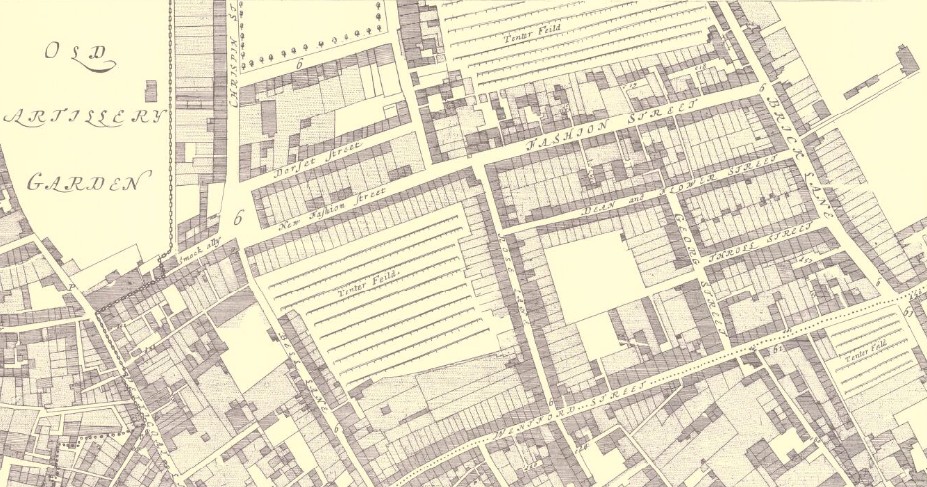
It’s clear that, despite their shortcomings, these houses were intended for the more prosperous folk of Spitalfields. What isn’t clear from earlier maps is – where did the poorer people live? We know they were were there. The Great Plague of 1665 had hit poorer areas particularly hard, where housing was overcrowded and sanitation at its worst. Daniel Defoe noted in his Journal of the Plague Year (published 1722) that mortality figures were high in the north of Spitalfields, where it borders Shoreditch. We also know that there was a long tradition of humble weavers and silk ribbon makers in and around this area. In fact the large ‘Tenter Fields’, seen on the map below, evidence the presence of the weavers.
The map is a snapshot of what part of Spitalfields looked like just ten years after the Great Fire of London. This is the southern part, bordering Whitechapel. Spitalfields is now an extension of the City, no longer separated from it other than by the presence of the wall. We see what seem to be more substantial houses on George Street and Winsford Street (along the bottom of the map) and also on the south side of Throll Street (recorded as Thrawl Street on most maps) but it’s difficult to be sure since, amongst other features, we can’t see how many storeys the various houses have. Regardless of the intended residents, most houses have a private garden, and there is also plenty of open space for communal growing.
Click for BIG
The arrival of the Huguenots
By the end of 1687 more than 13,000 Huguenots had settled in London, most of them in Spitalfields. There was much to attract them to this area: the already established French Protestant church in Threadneedle Street; the building development that was already under way; the history of a certain tolerance there of thought and belief; and the fact that there were many weavers and silk ribbon makers already in the area. The Huguenots were welcomed and encouraged to settle by the king James II & VII; and after initial concerns from local weavers that they would take their jobs and work for lower rates, it became clear that the newcomers had much to offer in terms of skill, technique, entrepreneurship and financial resources. Ultimately, the Huguenots brought great advantages to the nation, creating a new silk industry, and with it new markets, employment, skills and wealth.
Homes for the prosperous Huguenots
Not all Huguenots were wealthy. Many were journeyman silk weavers, producing cloth for the master weavers and merchants. However, it is the fine homes of the wealthy families that have survived, and which today we think of as Huguenot Spitalfields. Although, as we have seen, development of Spitalfields had been under way since the 1660s, the building of these early Georgian domestic terraces for which Spitalfields is known began around 1711.
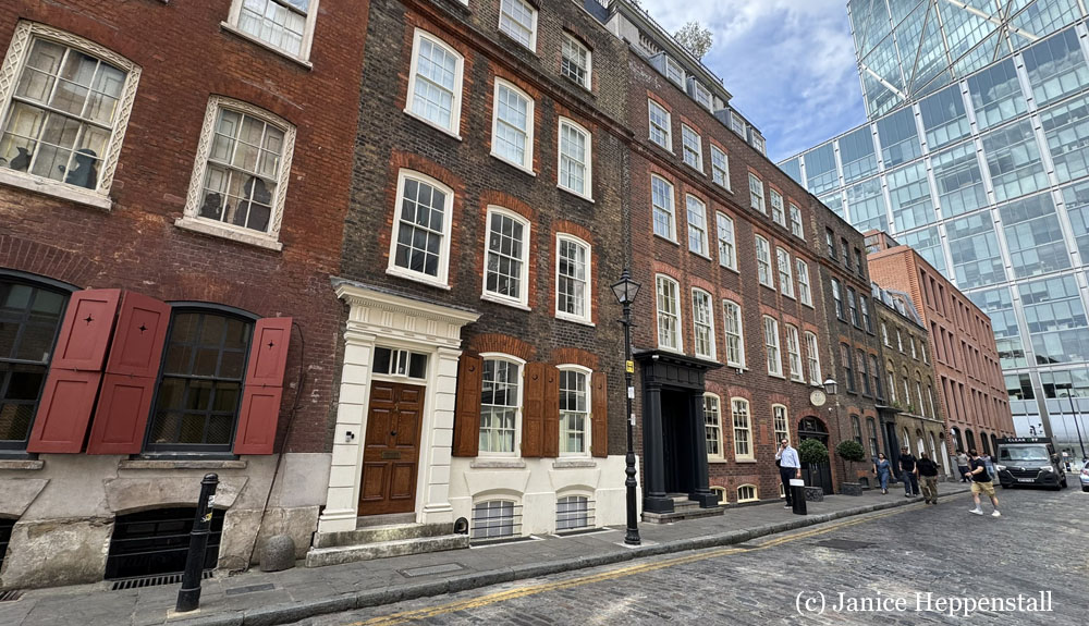
Rather horrifyingly, in the 1970s all of these streets were in danger of being lost to the bulldozer. Proximity to the City of London financial district (as evidenced in the above image) meant this land was on the radar of property developers. In 1977 The Spitalfields Trust was formed to rescue these Georgian streets. Their activities included campaigning, squatting, buying up properties and active restoration. One of their members was TV presenter and author of Spitalfields Dan Cruickshank, who lives there still.
Spitalfields now has four overlapping conservation areas. The photo above was taken in the Elder Street Conservation area, and those below are from the Brick Lane and Fournier Street Conservation Area. The other two areas are Artillery Passage and Wentworth Street. Conservation Area status provides legal protections for the streets, houses and communities. In addition, many of the individual houses have ‘Listed’ status, ensuring that any demolition, alteration, or extension is strictly controlled through a special planning system.
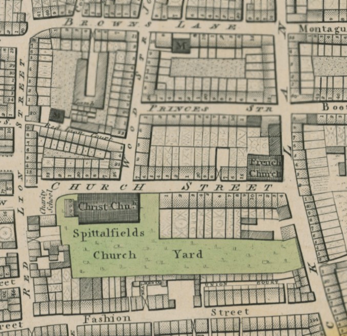
Perhaps the best place to imagine what Spitalfields was like for the master silk weavers and merchants of this time (and my favourite part of Spitalfields) is the houses in Wilkes Street, Princelet Street and Fournier Street. These were constructed between 1717 and 1730 – when the streets were called, respectively, Wood, Princes and Church Street, as per the map. The map is an updated edition of Richard Horwood’s PLAN of the Cities of LONDON and WESTMINSTER the Borough of SOUTHWARK, and PARTS adjoining Shewing every HOUSE. It shows the area as it was in 1819, but has the advantage of being very large scale, and there are no significant changes to this part of Spitalfields during the intervening years.
Click for BIG
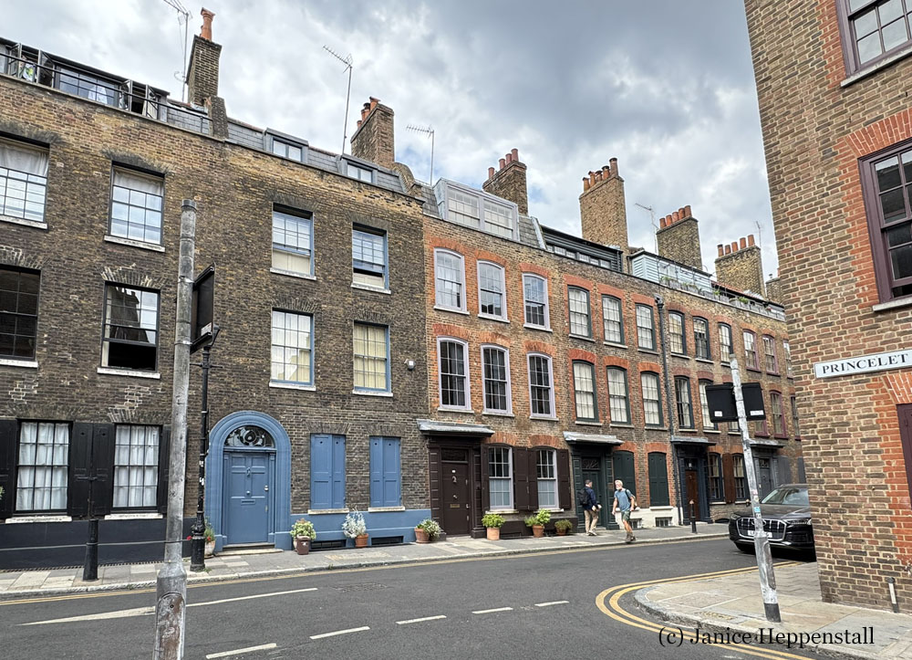
The houses have typical early Georgian features, including beautifully carved door casings, but many also have shutters. Each was built with a wide window on the upper floor of the rear elevation. These long ‘weaver’s windows’ were intended to maximise natural daylight, because this is where the loom would have been located. The additional windows now seen at roof level at the front of many of the houses were late eighteenth century additions, enabling greater workspace, and thereby the ability to generate more rental income, as the area declined in status and wealth.
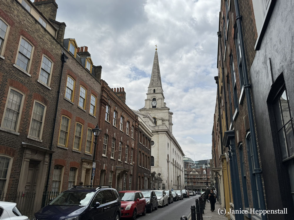
At the same time as the houses in these streets were being built, a new parish church was under construction. Until this time, Spitalfields had been part of the large ancient parish of St Dunstan’s, Stepney. The increased population of Spitalfields had highlighted the need for the creation of a separate parish. Constructed between 1714 and 1729, Christ Church, seen below, would not have most of its prosperous neighbours among its congregation.
The Huguenots retained a certain distance. Wishing to preserve their cultural and religious heritage, they worshipped initially at the French Church in Threadneedle Street but would go on to build several churches within Spitalfields. One of these is marked on the map above: the ‘French Church’ or ‘Église Neuve’ at the corner of Church Street (now Fournier Street) and Brick Lane, which was constructed in 1743-4. In these churches the prosperous would worship alongside their less wealthy fellow Huguenots, and it was perfectly normal to hear various dialects of French spoken throughout the area, on the streets and in the local markets.
Despite this, according to Sir John Vanbrugh, one of the Commissioners for the ‘Fifty New Churches’ of which Christ Church was one, the church was to be ‘a monument to posterity’, proclaiming the power and presence of the Church of England even though Huguenot Dissenters held sway in the area.
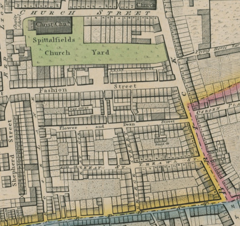
One of the regular worshippers at Christ Church was my client’s ancestor – the abovementioned successful broker whose residence here had intrigued me since he was not a pauper, a Catholic, a Dissenter, an immigrant, a weaver; nor, seemingly, has any of the other characteristics that seemed to attract people to live in Spitalfields in these times. His youngest child was baptised at the church in 1729. Initially, since his older children were baptised at St Dunstan’s in Stepney, I assumed he had just moved to the area, perhaps to occupy one of the adjacent newly-built fine houses; but this was not the case. It was the church that was new, not his place of residence. He was, in fact, living in Thrawl Street, and we know from John Ogilby’s map of 1676, above, that the houses in Thrawl Street (Throll Street on the earlier map) had been there at least since then. The reason for the first baptism at Christ Church in 1729, then, was simply that Thrawl Street now came within the parish of Spitalfields Christ Church rather than Stepney St Dunstan.
The map below shows the proximity of Thrawl Street to the church. The houses occupied by the prosperous merchants and master weavers are on Church Street and the streets immediately north of that.
Click for BIG
Were those streets to the north of the church effectively an ‘enclave’ for the Huguenots? It seems not – it was just that they seem to have been the people with the financial resources to live in them.
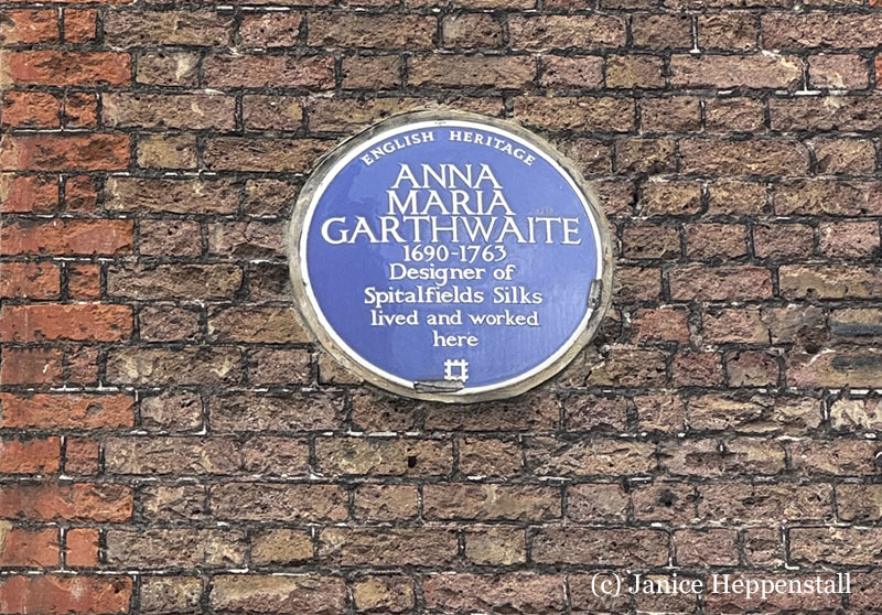
Anna Maria Garthwaite, below, was also not a Huguenot but she had a skill that enhanced those of the master weavers. Moving from Lincolnshire to Spitalfields in 1728, she lived at 2 Princes Street, now Princelet Street where, despite having no formal training, she set herself up as a silk designer, working in watercolour to create floral designs for master weavers to create in hand woven silk. So successful did she become – and so unusual for a single woman who was already almost forty years old when she relocated to Spitalfields – that her former house now bears a blue plaque.
The silk weaving industry required more than wealthy master weavers, designers and merchants. There were also journeymen. Together with the pre-existing workforce, there were thousands of the humbler journeymen weavers throughout the City of London, Spitalfields and Bethnal Green; and they were accommodated in weaver’s cottages. Very few of these have survived. The poor building standards and materials meant they were less likely to do so, while the sheer number of them meant that they were not valued. More humble jobbing weavers were accommodated in two-room weavers’ cottages in Whitechapel or Bethnal Green. Others lived where they worked in garrets at the upper floors of buildings with the essential weaver’s windows. (See some sketches here.) Over the following decades they were the first to deteriorate and become slums. Of course, no physical traces of their former existence remain.
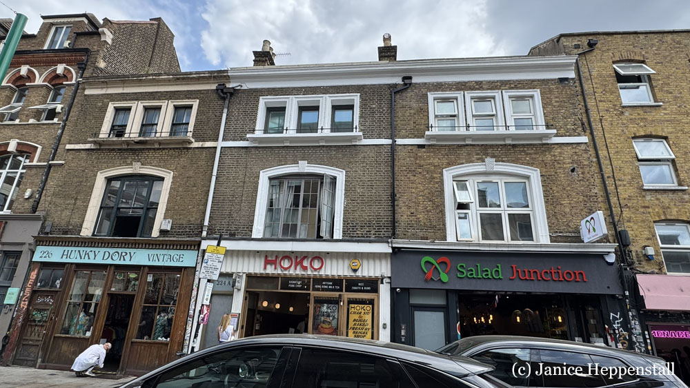
The image below shows a terrace of three more modest but better quality homes on Brick Lane. The weaver’s windows on the top floor are the give-away feature.
By 1800 a further wave of Huguenot refugees settled further east in a part of Bethnal Green known as Globe Town. There, weavers operated around 20,000 home based looms. It was also in Globe Town that mulberry tree orchards were planted for breeding silkworms.
Find out more about Spitalfields and its Huguenot history
My research has focused purely on answering some questions I had about the origin of Spitalfields and the coexistence of such different groups of people on the same small area of land: on the place rather than the people, even though some specific people have been in mind. Whether your interest is local history, present-day Spitalfields or family history, there are lots of online resources with information about Spitalfields and the Huguenots. To access specific records about ancestors you would have to visit the appropriate archives as signposted in some of these links.
First, Dan Cruickshank’s excellent book:
Spitalfields: The history of a nation in a handful of streets (2016) London, Penguin Books
The Spitalfields Trust, initially set up as a charity in 1977 as part of the above-mentioned campaign by a group of architects, architectural historians and journalists to save the early Georgian buildings of Spitalfields, is still going and they are now the guardians of two important buildings in the area: 19 Princelet Street, which is not yet open to the public; and Denis Severs’ House, which is open at pre-advertised times for tours and other events.
The Huguenots of Spitalfields website has a huge amount of introductory-level information covering the history of the Huguenots in Spitalfields and other parts of this country – just enough to get you started and to point you in the direction of where you might look for more.
Spitalfields Life is a daily blog written since 2009 by David Hoffman, about ‘the exuberant richness and multiplicity of culture’ of life in Spitalfields. He also offers tours. There are thousands of blog posts. A search bar towards the top of the page should guide you to what you’re looking for. This was the result of my search for “huguenot”.
The Huguenot Society of Great Britain & Ireland has, as its principal object, ‘the interchange and publication of knowledge relating to the history of the Huguenots in France and adjoining countries’. For people researching Huguenot family history, they have a page signposting sources of information, and can provide further support and information if you become a member. There is a page with advice for Tracing your poor Huguenot ancestors in London Huguenot records that would be very useful for many researchers.
The Huguenot Library is, at the time of writing, temporarily located at The National Archives. Its usual location is at University College London in Gower Street.
Amongst other treasures, they have a List of family names for which research files are available. It’s a huge list of surnames that, if you find them in your own family research, could suggest Huguenot ancestry. It’s not exhaustive, of course: other typical Huguenot surnames may simply not have been researched, or the research not lodged with the Huguenot Library; and in any case the origin of the version of the surname in your family may be elsewhere/ not Huguenot.
The Huguenot Map of Spitalfields, the brainchild of Fiona Atkins, proprietor of Townhouse, and hand drawn by Adam Dant. The map includes names of 300 historic Huguenot residents of Spitalfields, each appended to their former house, as submitted by their descendants. The above link is to a review of the unveiling of the map, with an enlargeable version of the map itself lower down the page. You might still need a magnifying glass!
If you’d like to see inside two of the fine Huguenot houses, I found these two videos, made by an estate agent specialising in ‘unique properties’. (Who knew they had coal bunkers under the street?!)
This next one has been styled as it might have been back in 1730. Look out in both these houses for the weaver’s lofts.
*****
I hope you’ve enjoyed this quick tour of Georgian Spitalfields, as it was when the Huguenots lived there. My next post will fast-forward to the late nineteenth century, and the massive Jewish migration into the area.

