
I couldn’t have imagined as I strolled through Spitalfields with my camera in London’s East End last July, that it would turn into several months of quite obsessive reading and research. But it did, and I apologise in advance for another post that will require coffee and snacks. The last two have brought us to this point. The first was an overview of the history of Spitalfields, including the arrival of the Huguenots in the late seventeenth century and up to the mid eighteenth century when the fine merchants’ and master weavers’ houses were in place. The second looked at the descent into poverty throughout the nineteenth century in Spitalfields. We’re now at the point at which a new wave of immigration was about to commence: Ashkenazi Jews fleeing the pogroms in Eastern Europe, and the general theme of this post is the physical transformation of Spitalfields into the ‘Jewish East End’.
These were not the first Ashkenazi Jews to arrive. A small group of Dutch Ashkenazi Jewish migrants came in the 1840s. These were economic migrants, seeking a better life. However, from the 1880s thousands of Jewish families fleeing increased violence and persecution within the Russian Empire would arrive: as many as 150,000 by 1914. Between the 1880s and the mid-twentieth century the population of Spitalfields was predominantly Jewish, with more than forty synagogues. Where, in the late seventeenth and first half of the eighteenth centuries, the language on the streets had been French, now it was predominantly Yiddish. As the Jews moved on, the next wave of migrants arrived, this time from Bangladesh; and it is they who are the main community now in the Brick Lane area. Today there is little physical evidence of this large Jewish community. Of the forty synagogues, only one remains in use: Sandy’s Row Synagogue. It occupies a former Huguenot chapel – l’Église de l’Artillerie which then became a Baptist church before being converted by the Dutch Ashkenazi community to a synagogue in 1867. What does remain however, is a huge amount of documentation, maps, census returns, photos and written accounts.
*****
About the maps
It is the maps that take centre stage in this post, although they are underpinned by a lot of reading. There are five maps in all. William Faden’s Fourth Edition of Horwood’s Plan, dated 1819, is my baseline. This is how the area looked at the beginning of the nineteenth century, before the massive decline into poverty. After that, there are two Ordnance Survey maps dated 1873 and 1894, followed by two early examples of social cartography: George Arkell’s Jewish East London map (1899) and Charles Booth’s Poverty Map (1898-99).
All maps show exactly the same part of Spitalfields: the south-eastern part, bordering Brick Lane; and all have been highlighted with turquoise outlines to indicate four locations of interest to me. These are:
- Thrawl Street: lower centre-left. For reasons that will soon become clear, I have also highlighted Keat Street and Flower and Dean Street.
- The three streets of elegant Huguenot houses which are now called Wilkes Street, Princelet Street and Fournier Street (formerly Wood, Princes and Church Streets) are bounded by the turquoise ‘square’ top centre-left.
- Directly opposite the eastern end of Thrawl Street is a house of interest to me: number 18 Brick Lane.
- A series of buildings on Booth Street: top right. The buildings that interest me are not yet built on the first two maps. They will be built in the 1870s on ground occupied on the earlier maps by dwellings built c.1681-1705 for working class families and silk weavers.
*****
Who this post is aimed at
In terms of family history research, the first two Spitalfields posts demonstrated the importance of historical facts as context for researching our ancestors and understanding their lives – whether that be local or national history. This is equally important for the present post. In particular, I hope this will be of interest for:
- readers with ancestry in Spitalfields in the second half of the nineteenth and early twentieth centuries, whether Jewish or not;
- anyone who would like to know more about the local history of this fascinating area;
- an example of using historical maps to illustrate and make sense of historical texts and name-rich documents.
*****
1819…
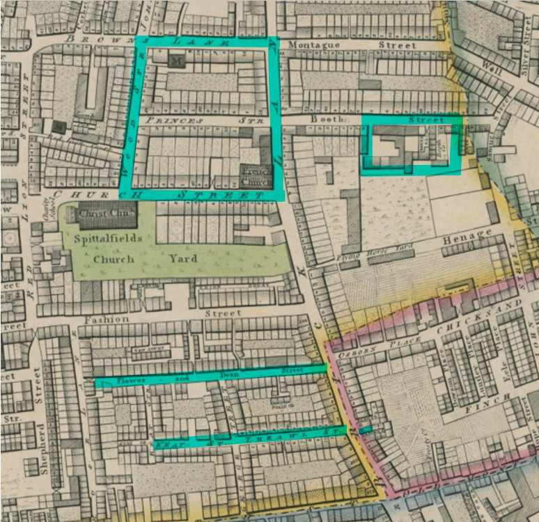
We start with Thrawl Street
Thrawl Street first caught my attention because it was the residence, in the early to mid eighteenth century, of an ancestor of one of my clients: a successful broker. I had no idea that not only was this street right next to one of my personal houses of interest, but also that by the end of the nineteenth century it would be right at the heart of the area settled by the Ashkenazi Jewish immigrants. How it got from the one to the other is an important and fascinating story.
According to the London County Council’s Survey of London (Volume 27, 1957) the houses on the north side of Thrawl Street, were built by Henry Thrall or Thrale, and were in place by November 1658. I suspect it was in one of these houses that this gentleman broker lived. His son also lived in Thrall Street until around 1756 when he moved to a house in Keat Street – the continuation of the Thrawl Street turquoise line on my annotated maps. When the son died in 1771 he left several thousand pounds – a substantial sum for the time, suggesting that Thrawl and Keat Streets would be desirable addresses. And yet, according to that London County Council Survey of London, this was not necessarily the case.
It seems that the houses in Thrawl and Flower & Dean Streets were not well constructed. Some or all of those in Thrawl Street were of timber construction, and by 1736 only three were still standing. Partial rebuilding had taken place, and some building up of street frontages with the original structures left in place behind them. Upper Keate Street was built in the 1720s. Again, the construction was probably not of the best quality. By 1805 these streets were said to contain many very old houses in a state of bad repair. By 1854 the fronts of five of them were in such a ruinous state that an order for their demolition was made. For all these reasons, it isn’t possible to say whether any of the houses shown on the 1819 map are those formerly occupied by this successful broker and his son. What is clear, though, is that by 1873 the area had changed out of all recognition.
1873…
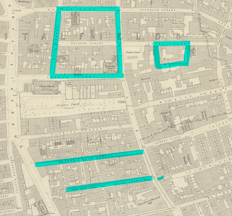
Reproduced with the permission of the National Library of Scotland
Link to original at NLS website
As the nineteenth century progressed what had previously been the gardens of these houses on the northern side of Thrawl and Keat Streets, together with those bordering Flower & Dean Street were infilled with narrow alleyways and tiny courtyards crammed with poor quality housing. The conditions are unimaginable: little or no natural light; inadequate water supplies; rotting structures; the stench from the accumulation of sewage and lack of airflow; overcrowding within each individual room; deceased family members kept alongside the living for lack of money to bury them; and vermin. In the words of journalist and social observer James Greenwood, this was ‘perhaps the foulest and most dangerous street in the whole metropolis … as appalling a stronghold of ruffianism and vice as ever disgraced civilisation.’ It was, he said, ‘a square quarter of a mile … all knitted together in a tangle of alleys and courts of the worst kind’. It was, in other words, a rookery.
There had been calls throughout the second half of the nineteenth century for demolition of the whole rookery; and yet it was understood that demolition of slums didn’t make the problem disappear; it simply made thousands of people homeless, and they had to move elsewhere, either to existing slums, or to create new ones.
These streets had also become the centre of Spitalfields’s common lodging house district. In 1875 it was estimated that the registered common lodging houses of the Flower & Dean Street area contained in all, 123 rooms, with accommodation for 757 occupants. Common lodging houses were places where people with no homes to call their own could spend the night, provided they had a few pennies to pay. In these rooms there was no separation of unrelated sexes; and rooms could be rented by day by prostitutes.
It is the ‘few pennies’ that are key to the playing out of the events of the night of August 30th 1888. Mary Ann Nichols, known as ‘Polly’, entered Wilmott’s Lodging House at 18 Thrawl Street where she had been staying. As she didn’t have the required fourpence (4d) for her ‘doss money’ – the payment required to spend the night there – she was asked to leave. Polly, who was working as a prostitute, asked for a bed to be saved for her and left the house, confident of quickly earning the money needed. Her body was discovered around 3.40 am the next morning. She was the first of the victims to be killed at the hands of ‘Jack the Ripper’. No less than three of the five victims who would be brutally murdered during his reign of terror – August 31st to 9th November 1888 – normally resided in the Flower & Dean rookery; and all of them were associated with this part of Spitalfields.
*****
The arrival of the Jews from Eastern Europe
When, at the beginning of the 1880s, thousands of Jews started to arrive in London, it was primarily in this broad area around the Flower & Dean Street Rookery that they settled. They were welcomed neither by the local population, nor really by the existing, now financially more secure, Jewish community. Concerned at the possibility of social unrest, the Board of Guardians for the Relief of the Jewish Poor and the United Synagogue worked together with wealthier members of the established Jewish community to tackle the problem. A plan was agreed to construct philanthropic housing projects for the working class. Following demolition of the western end of the Flower & Dean rookery the first of these housing projects, the Charlotte de Rothschild Buildings, was completed in 1887. You can see them on the 1894 Ordnance Survey map, below.
By 1888 the 198 flats of the Rothschild Buildings were fully occupied, mostly by Jewish immigrants … just in time for the horrific murders committed right on their doorstep. This provoked more antisemitic outrage and violence from the wider population who, considering the nature of the murders ‘un-British’, pointed the finger at the Jews.
The mystery of the identity of ‘Jack the Ripper’ has never been solved. Ultimately, however, the dreadful events of 1888 spurred on the rebuilding of the Flower & Dean Street area. More philanthropic dwellings companies were established, and as seen below, by 1894 the entire rookery between Flower & Dean Street and Thrawl Street had been demolished, to be replaced with subsidised housing. This demolition work did of course mean that for a significant period, the amount of housing reduced just at the time that population was increasing. Almost all of this ‘model housing’, built between 1887 and the early years of the twentieth century, was demolished in the 1970s.
*****
1894…
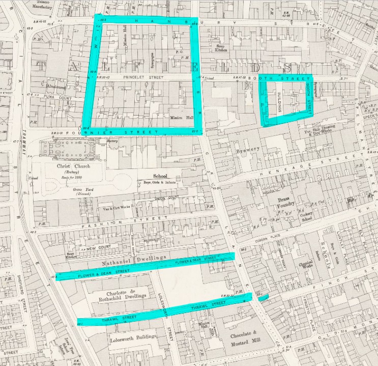
Reproduced with the permission of the National Library of Scotland
Link to original at NLS website
The infilling of formerly open spaces and gardens at the back of the houses with more houses of the poorest quality was not a practice peculiar to the Flower & Dean rookery. As described in my second Spitalfields post, and indeed as evident from the 1873 and 1894 maps, it was widespread throughout this area. Some of these ‘houses’ were the small sheds erected by silk weavers in happier times, on the gardens where they had enjoyed cultivating flowers. We will now turn to the area highlighted by the turquoise ‘square’ upper centre-left on all these maps, which happens to be my favourite part of Spitalfields.
The elegant Huguenot streets
Close examination of the three maps above reveals something fascinating. From the early eighteenth century it was the location of the fine Georgian town houses occupied by the Huguenot merchants and master weavers. Although these houses were adjacent to the Anglican parish church (Christ Church), that was not the place of worship of the Huguenots, whose religious beliefs were Calvinist. In 1743 they erected their own chapel – La Neuve Église – on the corner of Brick Lane and Church Street. It is shown on the 1819 map as ‘French Church’. However, by this time many of the Huguenots had left, and the building became a Wesleyan Methodist chapel shortly afterwards. It is shown on the 1873 map as ‘Methodist Chapel’, and on the 1894 map (same location but now ‘Church Street’ has become Fournier Street) as ‘Mission Hall’. In 1897 this same building became the Spitalfields Great Synagogue. It is incorrectly shown on Booth’s Poverty Map of 1899, below, as ‘Wesl[eya]n Chapel’, explained simply by Booth applying his findings to a slightly older existing map. Eventually, as the Jewish population, too, moved away, the synagogue would fall into disuse before being converted to the Brick Lane Mosque (London Jamme Masjid), which it remains to this day. Three hundred years of immigration into the area by successive groups is reflected through the continued use of this one building as a sacred place.
19 Princelet Street
However, this was not the only synagogue within the confines of my turquoise square. The 1873 and 1894 maps both indicate a ‘Synagogue’ on Princes/ Princelet Street. (There is also a United Methodist Free Church on Hanbury Street in 1873, renamed as ‘Mission Hall’ in 1894.) This Victorian synagogue, built onto the back of 19 Princelet Street, is now in the ownership of The Spitalfields Trust, who aim to bring it up to standard to be opened to the public.
19 Princelet Street is clearly a special case. A house that is also a synagogue marks out the area as having a sufficiently sized Jewish population to merit the existence of the synagogue, while also indicating a sufficiency of funds to make it happen. What do the occupants of this house, as seen in the censuses, tell us about the growth of the Jewish community in Spitalfields?
- The house was built in 1719, and by 1740 was in the occupation of successful silk merchant and master weaver Peter Abraham Ogier. By 1851 it was occupied by two households: a Greengrocer; and a Pencil Maker with his family. In 1869 the building was purchased by a community of newly arrived Polish Jewish immigrants, following which, in 1870, a synagogue was consecrated within the house.
- The 1871 Census finds a ‘Jewish Minister’ living next door at number 18. Number 19 is occupied by three households. One is a Polish tailor and his wife, whose children’s ages and birthplaces suggest arrival in England before 1857, then settling in Spitalfields around 1862. The second family is a Dutch-born couple with the husband’s grandmother and a child whose details suggest arrival in Spitalfields by 1857. Although names have been anglicised, these could be part of the Dutch Ashkenazi settlement. The final household hailed from Llandudno, Norfolk, Warwickshire and Shoreditch, and were almost certainly not Jewish.
- By 1881 the main household occupying number 19 was a ‘Reverend’ from Russia – a Rabbi?- and his family, who had arrived in London between 1874 and 1877. A Second household, almost certainly Gentile, probably occupied the upper floor.
- In 1891 a note on the Census Enumerator’s Book indicates ‘House in repair’. It seems likely that the house had been vacated to allow for the extension of the synagogue into the rear garden with a basement meeting hall. This is known to have been completed by the early 1890s. A blogpost by Charles Saumarez Smith includes photographs of it in its current condition, which indicate that all the natural light came from coloured glass in the ceiling.
- Finally, in 1901, the house is back to single household occupancy: a German-born Tailor & Clothing Manufacturer/ Employer with his large family and two servants. All of the children were born in Spitalfields, indicating the father, now widowed, had arrived by 1881. The surname and forenames of some of the family members indicate that this is a Jewish family, and a note indicates the father was ‘Not Brit[ish] Subj[ect]’.
*****
Certainly 19 Princelet Street’s occupants are consistent with a change in the population from Huguenot to British artisans. There is also evidence of different waves of Jewish migration – the earlier Dutch Ashkenazi settlement but also the early Polish residents linked to the purchase of the building. There is little evidence here, though, of the later arrivals throughout the 1880s and 1890s, and the attendant poverty we might expect to see.
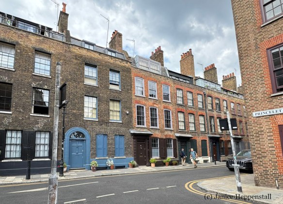
9 Wilkes Street: another example
The image above shows the junction where Princelet Street meets Wilkes Street. Number 9 Wilkes Street is two doors to the left of shot. Here, for comparison, is a summary of the census enumerations for that address, from 1841 to 1901:
- 1841: Four households totaling 19 people. Occupations included Logwood Cutter, Silk Dyer, Butcher, Plasterer, Labourer.
- 1851: Two households, comprising a total of 16 people. Occupations were Last Maker and Plasterer. All residents were born fairly locally.
- 1861: One household comprising 8 people. Occupations were Labourer, Box Maker, Wine Cooper. All born locally.
- 1871: Three households comprising 19 people. Two of the households originated in Germany or Poland, with younger children born locally. Their trade was tailoring. The third household was mostly local (wife from Wiltshire) and occupations were Bricklayer and Shoe Maker.
- 1881: No enumerator booklet located
- 1891: Two households (one multi-generational) comprising 22 people. All adults were from Poland, with younger children born in London/ Whitechapel. Occupations were Tailoring, Furrier and Shoemaker. It is clear from the children’s ages that one family arrived by 1882 and the other before 1875.
- 1901: One household comprising 8 people. The husband (a Tailor) and wife were from Russia. They arrived before 1890 and all children were born in Spitalfields.
Again, we see multiple occupation with local-born artisans, followed by the arrival of Jewish residents by 1871. By 1901 the house is back to single occupation with one family who were part of the post-1880 migrations. In terms of supporting what we know about the growth in the Jewish population, this is as anticipated.
*****
Jewish East London map
With the exception of a one-off Religious Census in 1851, the matter of religion was never part of any UK census until an optional question about personal religion in 2001. We cannot, therefore, depend on the censuses for an absolute definitive answer on whether a family is Jewish. There are however clues – details that, particularly when combined, strongly suggest this to be so: birthplaces in countries from where Askenazi Jews are known to have fled; particular surnames like Simeon, Levine or Cohen, or Eastern European surnames paired with forenames popular within Judaism such as Rachel, Rebecca, Isaac, Abraham; and tailoring as an occupation. A family with only one of those details is likely to turn out not to be Jewish. For example, I was recently asked to explore Jewish ancestry within a particular family. What I found was a 3x great grandfather with the first name Israel. The family hailed from a Lancashire cotton mill town and had a very English surname. In such a setting, an Old Testament name like Israel indicates not Judaism but Nonconformity. Somehow, this one name had turned into a family story of Jewish heritage.
There is, however, a map covering Spitalfields, Whitechapel, Mile End and Bethnal Green on which, in 1899, individual streets were classified according to the proportions of Jews and Gentiles. The map, again here cropped to the same part of Spitalfields as above, and my streets of interest highlighted with turquoise lines, is below. It was commissioned by the Toynbee Trust in 1899, to show where the Jewish community lived in East London, and developed by statistician and social geographer George Arkell.
Arkell had previously worked with Charles Booth on his Poverty Map (which we will come to next). Booth had developed a colour-coded system to categorise individual streets by levels of wealth or poverty. Arkell now used the same system for his own map. The key to the colours is included immediately below the map.
1899
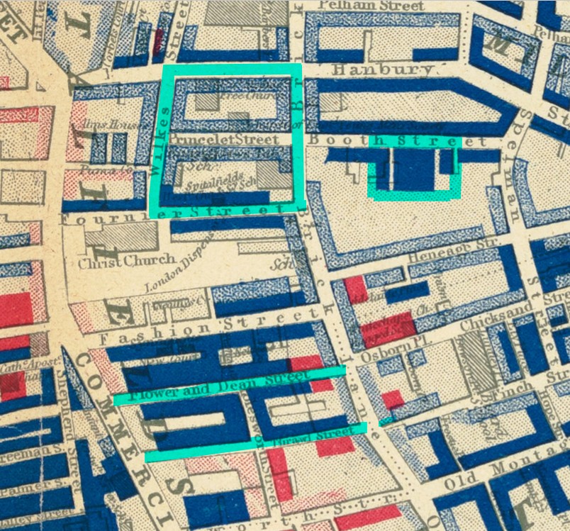
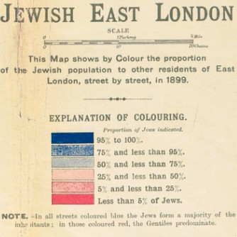
Arkell’s work is the only source based on field research that indicates percentages of Jewish residents in Spitalfields at the turn of the century. When we read that ‘95% of parts of Spitalfields was Jewish’, this is the origin of those statistics. Looking at the four areas highlighted with my own turquoise borders, we see that by 1898-99 the population for each of them was at least 75% Jewish, and in some cases 95% plus.
The full version of the map is available at the Cornell University Digital Library. It shows how the Jewish population at this time was was almost entirely concentrated within two square miles around Spitalfields and Whitechapel. As mentioned above, at the very heart of this concentration was Thrawl Street, Flower & Dean Street, and the streets immediately to the west of these.
This map, then, illustrates perfectly, not only the historical facts about the Ashkenazi Jewish immigration recorded above, but also sits nicely with evidence from the censuses of the two houses in Princelet and Wilkes Streets
*****
Charles Booth’s Poverty Maps
However, there is one issue on which, for me, questions remain. Having fled violence and persecution, most of the Jewish immigrants arrived with little or no money. My expectation when examining the census records was that, alongside the increased number of Jewish households, there would, particularly after 1881, be an increase in overcrowding and homes in multiple occupation. This is not evidenced in the Princelet and Wilkes Street examples, where numbers of households occupying individual properties could decrease as well as increase. Indeed, by 1901, both of the properties had returned to single household occupation, at a time when Spitalfields was becoming ever more overcrowded.
Between 1886 and 1903 Charles Booth carried out an Inquiry into the Life and Labour of the People in London. He wanted to understand the lives of Londoners, focusing on work and working conditions; home and urban environments; and the religious life of the city. Within this investigation he developed his series of Poverty Maps, categorising every street according to seven classifications, from Lowest class to Upper-middle and upper classes, and indicating these classifications on the map through the use of seven colours. The edition below is is part of Sheet 5: East Central District, dated 1898-99, and the key to the colours is below the map. The turquoise markings are mine.
1898 to 1899
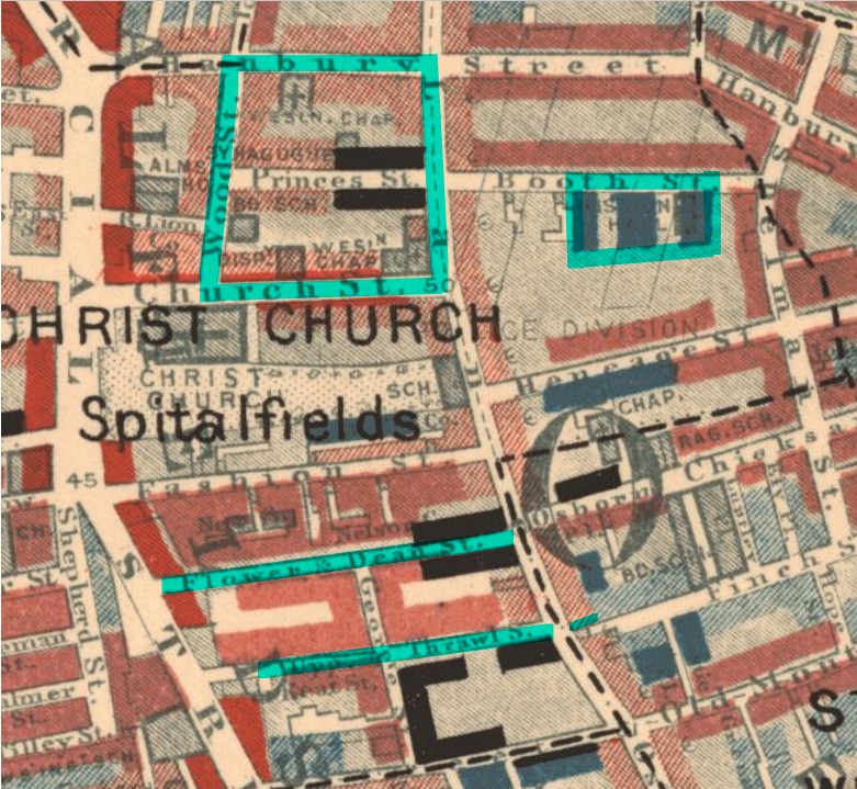
Sheet 5: East Central District (1898-99) (Part)
This is a section of the map available on Wikimedia commons
Click the key for BIG if you need to:

As with the censuses, maps are a snapshot. The physical and societal situation changes over time. The version of Booth’s Poverty Maps used here was surveyed in 1898-99, but the situation was clearly changing rapidly. Using the key, we can see:
- the make-up of Wilkes (‘Wood’) Street and the adjacent Huguenot houses is ‘Fairly comfortable: good ordinary earnings’ but with two blocks of black at the Brick Lane end: Lowest Class: Vicious, semi-criminal. (Note that the old street names are used on this map, so Wilkes Street is shown as Wood Street and Princelet as Princes Street.)
- Most of the houses on the eastern side of Commercial Street (left of map) are red: Middle Class: Well-to-do.
- On Thrawl Street, most of the recently built blocks are coloured ‘purple’ (I would describe it as deep pink): Mixed, some comfortable, others poor; but four blocks in the immediate vicinity are black: Lowest Class: Vicious, semi-criminal. It is good to see that, like the Rothschild Buildings at the western end of Thrawl Street. the model housing that replaced the rest of the Flower & Dean rookery is built around a large courtyard, thereby enabling good free-flow of air.
- To the east of Brick Lane there are patches of dark blue (Very poor, casual: Chronic want) and pale blue (Poor: 18s to 21s a week for a moderate family). One of these areas of dark blue is the properties within my turquoise border on Booth Street. These tenements had appeared for the first time on the 1894 map, having been built between 1873 and 1878.
- 18 Brick Lane, just opposite the end of Thrawl Street, is pale pink, the same as Wilkes and Princelet Street. ‘Fairly comfortable: good ordinary earnings’.
*****
The question is – do the areas of greatest poverty coincide with the highest proportions of Jews? The answer would seem to be that in general they do not. Even allowing for the presence of the longer established Dutch Ashkenazi Jews and the earliest arrivals from Eastern Europe who have had time to make a better life, this is unexpected.
My next – and final – post about Spitalfields will look at this issue of poverty at the turn of the century. It will focus on the two remaining turquoise-highlighted properties on these maps: 18 Brick Lane and the Perry’s Avenue tenements in Booth Street. Attention will shift from the built environment and the public sphere to families and individuals.
My December post will take a break from Spitalfields, but I anticipate this final post on the topic will be ready by January.
*****
Resources
Books
Dan Cruickshank: Spitalfields: The history of a nation in a handful of streets (2016)
Survey of London: Volume 27, Spitalfields and Mile End New Town on British History Online
Maps
National Library of Scotland Maps
Jewish East London map – the full version is available with useful background information at Cornell University’s digital library
The version of Booth’s Poverty Map on the London School of Economics and Political Science website is interactive. Click on a pin and you’ll have the option to go to read the assessor’s notes
Websites
The 1912 streets of Spitalfields – fantastic images of Spitalfields captured in 1912 by C.A. Mathew
Ancestry.co.uk was used for the census information
The Genealogist was used to assist with locating census returns without the aid of a named person

