Ancestral Tourism 4: Houses & Business Premises

This is part four in my ‘Ancestral Tourism’ series. It follows on from Part 1: Churches and Churchyards, Part 2: Municipal & other Public Cemeteries and Part 3: Graves and Gravestones. The focus in this little series is on planning ahead so that you can spend the time when you’re there exploring, wandering, taking photographs and soaking up the vibes of the place.

In this post we’re looking at preparing for visiting former ancestral homes and business premises that are still standing. Trying to locate buildings no longer in existence will be covered in a future post.

Before you go

How do we know where our ancestors lived?
A range of documents may include the specific address or property name, or other clues as to the location of a former home or business of our ancestors. Examples are:

  • Church records, such as Baptism, Marriage, Burial and maybe wider parish records
  • Civil Registration: Birth, Marriage and Death Certificates
  • Census records
  • Correspondence between the person and an official body, sometimes found in archives, e.g. National Archives
  • Directories
  • Electoral Rolls
  • Family business records
  • Family documents, including letters and perhaps a family bible or other religious text
  • Immigration and Naturalisation documents
  • Military Records, including attestations and next of kin
  • Newspaper reports
  • Poll Books
  • Probate Records, Wills, etc
  • Property and Land records, including deeds, local tax, etc
  • Public and Municipal Cemetery registers
  • School records

It’s certainly easier to track our more recent ancestors.
For earlier generations, even where we find an abode in the examples above, often an exact ‘address’ was not used. A street name without house number, or for smaller places even just the name of the village or hamlet may be the closest we’ll get. During the second half of the 19th century we find more documents that include information to guide us to a specific property. Earlier this year I visited Kinver in Staffordshire, where my 2x great grandfather and some of his siblings were born. The image below shows the extent of Kinver now, as viewed from the churchyard high on a hill above the village. The main High Street, dating from medieval times, is clearly seen in the image. Most of the properties beyond that are more recent. ‘Somewhere in this photo’ is the closest I will ever get to knowing where my ancestors lived here – but I’m happy with that.

Kinver viewed from the church. © Janice Heppenstall

Beware! House names and even house numbers can change
Even when documents do bear a house number or name, these may have changed – particularly if there was much additional building in the twentieth century. I researched the history of a house built around 1837 in what is now a built-up area of the Isle of Wight. The house number is 21, and my clients had already done some research into the nineteenth century inhabitants of ‘number 21’. However, using maps and other documentation I found that the house became number 21 only in the early twentieth century. For the first eighty or so years it was number 3. The change had become necessary to accommodate new building over the previous decades.

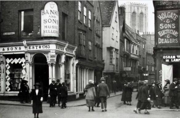
Similarly, a few years ago, I visited York to see my family’s properties there. Census records had my 4xG grandparents at 58 Stonegate. I found the property and photographed it, but afterwards realised Stonegate had been renumbered. Eventually I worked out that their shop (and the floors above above, where they lived) had been this well-known corner plot, below, that was later taken over by Banks & Sons. I had been sitting right opposite this shop (in Betty’s tearoom, for those who know!) without knowing it was my ancestral home. It took a lot of research to work this out. But this is what happens when we don’t do our homework before we set off! Now I have to go back to York to step inside this lovely shop. Luckily, visiting York is never a chore.

An early twentieth century scene from York, showing part of Stonegate and featuring the corner shop at that time occuped by Banks and Sons Music Sellers. York Minster is visible in the background
Junction of Stonegate with St Helen’s Square, York. Image in public domain, photographer unknown.

Changes in house name can be even more difficult to work with, particularly if several houses on the street seem to have changed name, and possibly more houses may have been built between the original ones.

So how can we be sure we have the right house?
Here are some ideas.

Photographs
If you’re lucky you may have an old family photo of the house. Even photos of people standing outside a property may provide visual clues in the form of distinctive architectural features. You can then use Google Street View to ‘walk’ along the road to find the property, if it’s still there.

Family and Local History groups on Facebook are also extremely useful for identifying the exact location of a photograph. I once witnessed someone posting an ancestral holiday snap and asking if anyone knew where in the world it could be. Within fifteen minutes it was identified as beneath a specific lamp post in a named piazza in Rome!

It’s also worth exploring whether there’s a website with old photos of your area of interest. The best one I know is Leodis, a photographic archive with over 62,000 images of Leeds, managed by the Local and Family History team at Leeds Libraries. I have found many old images of houses my ancestors lived in on there – in streets that now no longer exist. If you know of such a website for any of your areas of interest, please do share in a comment.

Maps
Mention has already been made of Google Street View. Modern day maps – including Google and other online maps – can be scrutinised alongside historic maps. My go-to place for online Ordnance Survey maps is here: https://maps.nls.uk/os/ I’ve written before about their Side-by-Side maps, but there are many other features. Something you could do is find a detailed historic map (the 25 inches to one mile series if possible) on the nls site, and see if you can compare the shapes of buildings then to existing buildings on satellite view now.

‘Walking the route’ with the census enumerator
With no photos and only documents to go on, it may be possible, using modern and contemporary maps, to ‘follow the route’ of a census enumerator. Using landmarks and occurences of smaller streets, you may be able to find the house, or at the very least to work out its general whereabouts, even if it’s not possible to narrow it down to a specific property.

Getting to know the neighbours
Using census returns for the street where your ancestors lived, it might be possible to track any changes in housenames or numbers of specific families whose occupation spans two or more decades. If the Jones family live at number 42, the Smiths at 44 and the Browns at 46, and then ten years later the same three families are at 58, 60 and 62, it is more likely that the numbering has changed than that all three families relocated together further along the same street. You can do the same thing far more accurately by consulting Electoral Registers. In the example above of my clients’ house starting out as Number 3 and eventually becoming Number 21, I could see from the Electoral Registers that this change happened in 1931. However, Electoral Registers are often not accessible online, meaning this may be something you could do only when you arrive in the area. Local archives and central libraries will usually have these registers.

What if your family’s presence predates the census?
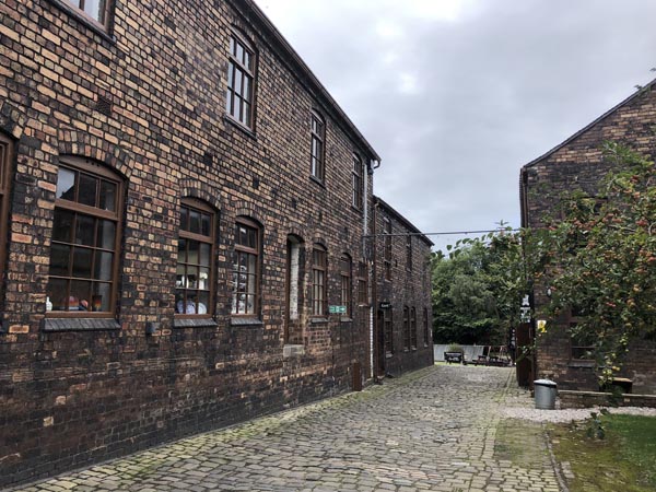
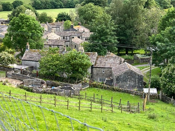
Below is part of Starbotton, in Upper Wharfedale, where my period of interest, before 1750, predates the census. Before going I ‘walked the route’ using Google ‘Map View’ on one device and ‘Street View’ on another to be sure to cover the whole village. By the time I visited, last summer, I knew this small village like the back of my hand. However, I had no idea which house had been owned by my 8x great grandparents and later their son, my 7x great grandfather. Apart from church records and similar, indicating that the family lived in ‘Starbotton’, I was very lucky to come across a collection of property reports made over the years by the Yorkshire Vernacular Buildings Study Group. These, in turn, drew upon other property documentation at the County Record Office. I was able to identify several specific houses formerly owned by my wider ancestral family in Starbotton, and to pay special attention to them when I visited. I never did find out where my 7x and 8x grandparents lived, though, and it’s possible their house may no longer be standing. However, I can name the late seventeenth century inhabitants of around half of the properties, and I know that most of mine lived in the part of the village pictured below.

A rural village scene with seventeenth century stone houses surrounded by hills and trees
Part of Starbotton, Upper Wharfedale, Yorkshire. © Janice Heppenstall

When you arrive

If the occupants were in the garden I would probably chat to them, tell them about my connection and ask permission to photograph the house from the street. If they wanted to know more about who lived there I would tell them. If they were not there I’d take the photos anyway. Just taking a few photos, wandering up and down the street, touching the wall… I find all these things bring me closer to my ancestors who lived there.

If your ancestors had a shop or public house, if the school they attended is now a business centre, or if for some other reason their former home or premises are open to the public, it would be lovely to step inside and spend a little time there.

I also enjoy seeing historic buildings and landmarks that my ancestors would have known, and just getting a feel for the area and the local history. You can do this even if the house they lived in is no longer there.

Depending on the size of the place you’re visiting, and its historic importance or embracing of tourism, you might be able to pre-book a tour with an accredited guide.

If you can’t get there

It really does make a difference going there, but if that’s not possible, just doing the research outlined above will leave you knowing a great deal more about your ancestral homes and the localities they lived in. You can also take a screen shot of your ancestral properties using Google Street View, and of course connect with online and local groups to find out more and see if anyone has any photos.

*****

If you have other ideas please do leave a comment.

Ancestral Tourism 3: How to read a cemetery

Ryde Cemetery, Isle of Wight. © Janice Heppenstall

This is the third in my ‘Ancestral Tourism’ series, and follows on from posts about preparing for visiting Churches and Churchyards and Public & Municipal Centuries featuring in our ancestry. In those previous posts, the focus was on knowing the history, finding the records and then finding any maps of the churchyards and cemeteries. In this post we’re going to be ‘reading’ the burial ground. What can we deduce from the location, the headstone (or absence of a headstone), the symbolism and anything else that will give us clues as to our ancestor’s life and social standing?

Please be prepared before applying what follows to your own family that there is a possibility that not all your ancestors will have well-kept headstones in peaceful and picturesque settings within the churchyard or cemetery. Some may have been buried with unrelated people in common graves, with or without a headstone. This is part of their story, and the story of the times in which they lived, but it can be upsetting to find.

Consecrated or Unconsecrated?

As outlined in my last post, from the middle of the nineteenth century the Burial Acts required that half of any new Municipal or Public cemetery was to remain ‘unconsecrated’. The other half would therefore be ‘consecrated’. What does this mean?

Consecrated

  1. Dedicated to a sacred purpose; made sacred; hallowed, sanctified.
  2. Dedicated, ‘sacred’ to a tutelary divinity.
  3. figurative. Sanctioned by general observance or usage.

Oxford English Dictionary (Online)

Although the online Oxford English Dictionary gives the above definition, in relation specifically to burial grounds in England and Wales it is a centuries-old term referring to land that has been blessed and set apart for Christian burial according to the rites of the Church of England (in Wales now, Church in Wales). ‘Unconsecrated’ referred to any portion not blessed or made sacred according to those rites. Before the mid-1800s, when most burials took place in the graveyard of the parish church, the official burial had to be conducted by an Anglican clergyman in accordance with the Church of England prayer book service. This applied even to those who had, in life, followed different religious practices. However, such people were not eligible for burial within the Consecrated area of the graveyard. They were buried in a separate Unconsecrated section. This applied also to babies who died before they were baptised and, before 1823, to suicides.

Also mentioned in my last post, the development of the new Public Cemeteries from the 1820s and Municipal Cemeteries from the 1840s coincided with a greater acceptance and recognition of different religious practices. Here, the term ‘Consecrated’ was kept but now, in the ‘Unconsecrated’ portion of the cemetery, the burial service itself was likely to have been carried out in accordance with the rites of the deceased’s religion. Today there is greater recognition of the different rites and practices developed by different religions and cultures in commemorating their dead. Although some dedicated cemeteries exist, there are also separate areas for specific faiths within public cemeteries. However, back when our ancestors were being buried it was simply ‘Consecrated’ or ‘Unconsecrated’, and eventually over time the terms ‘Anglican’ and ‘Nonconformist’ came to be used. Although in England and Wales today we use the latter term for Protestants who are not part of the Church of England, in earlier times it was used for anyone whose religious beliefs differed from the established church, the Church of England. It therefore referred also to Roman Catholics, for example. As can be seen from the image above and that below, separate registers were kept for these two sections of the cemetery.

Follow the clues

Finding your ancestor in one or the other may come as a surprise. If so, this is extra valuable information about your ancestors. Precisely what it tells you will depend on the context. For example, all in the same cemetery:

  • My Irish-born 2x great grandfather’s burial is recorded on the very page you see above. He was buried in the Unconsecrated part because he was Roman Catholic.
  • My 4x great uncle’s burial is also in the Unconsecrated part. This is because he and his family worshipped at the Wesleyan chapel.
  • I had a question mark about the denomination of an ancestor from Ulster. He was buried in the Consecrated portion of the cemetery, but his first child with his English, Anglican, wife was baptised in the Roman Catholic church. His burial seem to settle the question… or did it? There remains the possibility that he was simply not a church goer, and by the time of his death his adult children just didn’t know he was actually Roman Catholic.
  • The burial of another 2x great grandfather in the Anglican part of the cemetery in 1898 was interesting because he took his own life. This gave me a reason to research the burial of suicides. Suicides had traditionally been buried at a crossroads, sometimes with a stake through the heart. The Burial of Suicides Act, 1823, banned such practices. It permitted burial of suicides in consecrated ground, but only at night and without a Christian service. With the passage of the nineteenth century came a greater understanding of mental health, and the term ‘Of unsound mind’ came to be used by Coroners. In 1882, the 1823 Act was repealed, and replaced with the Internments (felo de se) Act. This permitted the burial of those who had taken their own lives at any hour and with the usual religious rites, including in a churchyard at any hour. However, suicide would not be decriminalised until 1961.

Burying in style!

There were great differences between the funeral and burial practices of rich and poor. For the wealthy, this could be a no-expense-spared event from start to finish: an opportunity to be seen to be ‘doing things properly’ according to the etiquette that had grown up around funerals. Obituaries in the newspapers will give you an idea of the size and scale of a grand funeral.

In the cemetery there are more clues. These include the location of the grave. A prime position with good views cost more. It may also have been possible to pay extra for a nine foot deep grave rather than the usual six feet, although you won’t be able to see that from the grave itself. A deeper burial was thought to help preserve the body.

A range of funerary monuments were also available, ranging from mausolea, cenotaphs, tomb chests and sculptures to headstones and more simple marker stones. Historic England have produced a guide to Caring for Historic Cemetery and Graveyard Monuments which includes descriptions of the various types.

If you’d like to know more about a whole range of roles, customs and traditions linked to death and funerals, Friends of Beckett Street Cemetery in Leeds have compiled an excellent overview of Victorian funeral traditions and etiquette. Some of these would have been de rigeur amongst the wealthier folk but others applied more widely. Even when I was growing up I remember people closing the sitting room curtains after a death in the home.

Symbolism

Victorians loved symbolism, and the various monuments and gravestones were the perfect canvas for this form of expression. On their website, Arnos Vale Cemetery, Bristol, make the point that when larger public cemeteries started to appear, much of the population was not literate. The symbols found on graves made them more meaningful for someone who may not be able to read the words. Even today, if we understand the symbolism, a whole new layer of understanding opens up to us as we walk amongst the gravestones. Perhaps there might be clues on the gravestones of some of your ancestors, letting you know what was important to them and their loved ones. You might even come across some symbolism pointing you to membership of the Freemasons or similar, which would then open up a new line of research for you. The Funeral Directors association and Family Tree Magazine have also published useful lists of symbolism and meanings.

It was a surprise to walk around Ryde Cemetery after reading them and to note the symbolism on a lot of the stones and monuments. This ‘broken’ column represents a life cut short, and the anchor symbolises EITHER hope, steadfastness, and the secure connection to God or eternal life OR a seafaring life, perhaps with the Navy – or perhaps both. Since Ryde is on an island, either is possible and now I’m thinking I should have spent longer and read the inscription to find out more…

Symbolism of elaborate headstone in Ryde Cemetery, Isle of Wight. Image © Janice Heppenstall

Different types of grave

For those with the ability to pay for a private grave, there were:

  • single plots, intended for one person in a coffin
  • companion plots, intended for a couple, perhaps side by side
  • family plots, where several members of the same family can be buried together.

A certificate or “grave paper” documented the purchase. (I have one of these, purchased by a 2xG grandfather on the death of his wife in 1875.)

A purchased plot does not necessarily mean our ancestors will also have purchased a headstone, so you may need to navigate to your ancestor’s final resting place with the aid of only the plot number and a site map. The location of such plots, amongst others with headstones, should enable you to differentiate them from the common graves detailed below.

One of the motivations for the publicly-funded Municipal Cemeteries was the ability to provide for all social levels, including some lower cost options so that the labouring classes could afford to bury their dead with dignity.

A Common grave was a plot that belonged to the cemetery, not an individual or family, and was used to bury unrelated people. There were several different types of common grave, and the costs for the different types varied:

  • Lock-up graves: these were the cheapest type of grave. They were filled over the course of a few days as more bodies became ready for burial. Between each burial the soil was not replaced. Instead, a wooden ‘door’ was locked in place over the grave. When the grave had the required number of deceased people, the earth was piled on top. These were also called Open graves.
  • Public graves: like lock-up graves, these were filled up as newly deceased unrelated individuals became ready for burial. The difference is that these graves were refilled with earth after each new burial. They were therefore a little more expensive.
  • Note that ‘Pauper’s grave’ was not an official term and probably more rightly refers to the burial administration rather than to the grave itself – a Pauper’s burial. Essentially, before 1834, paupers were buried at the expense of the parish, and after that at the expense of the Board of Guardians. There was no unnecessary expense. The actual grave would have been one of the above types of common grave with no inscription, probably a lock-up grave where that was an option. Local authorities remain responsible today for the burial of a deceased person leaving no funds for a funeral and no one else to arrange it.
  • Inscription graves: For a small additional fee, a deceased person could be buried in a common grave but with a headstone inscribed with the name, date of death and age of every occupant. Some of the headstones may have had bodies arranged on both sides with inscriptions on both sides of the stone. These are a feature of the municipal cemeteries in Leeds – in fact every reference I have come across online relates to Beckett Street or another of the Leeds cemeteries. Here, they are known as ‘Guinea Graves’, that being the original cost of burial in one of these Inscription graves. If you are aware of this type of grave (Inscription or Guinea Graves) elsewhere in the country, please leave a comment saying where and by what term they are known – thanks.
Guinea Graves at Hunslet Cemetery © Stephen Craven at Wikipedia Commons

Some notes

For overseas readers (or very young British readers, perhaps!), a guinea was a British coin, originally minted in 1663 with a value of £1 (One Pound). Eventually it came to have the value of £1 – 1 s (One pound one shilling, i.e. 21 shillings). Even after the guinea coin ceased to circulate, the term remained as a unit of account worth 21 shillings. As late as the 1970s it was used for the quoting of professional fees and luxury items.

I have previously written about how to ‘read’ a Commonwealth War Graves Cemetery [here].

*****

I have become rather more fascinated with municipal cemeteries than anticipated! My next post will be about getting the most from different cemetery records, before returning in the post after that to Ancestral Tourism: houses and places our ancestors knew.

Ancestral Tourism 2: Public & Municipal Cemeteries

Ryde Cemetery, Isle of Wight. © Janice Heppenstall

This follows on from my last post: Ancestral Tourism 1: Churches and Churchyards. It focuses on locating and visiting graves of our ancestors whose final resting place is in one of the large municipal or other public cemeteries in our towns and cities rather than in a church graveyard.

First, a bit of history

The emergence of large public cemeteries is an interesting part of our social history, connecting with several other developments of the nineteenth century that will be familiar to local and family historians. The migrations and population booms of the eighteenth and nineteenth centuries created not only a lack of housing for the living but also of burial grounds for the dead – and all the more so in the growing industrial towns and cities. The historic churchyard burial grounds posed problems on several fronts: they were generally small, overcrowded, often laid out in a haphazard manner; and as knowledge of hygiene and sanitation developed, there were concerns about the spread of disease, particularly since in towns and cities these small burial grounds were generally alongside the church and surrounded by closely packed housing.

The initial response to this problem was to turn to the private sector. Throughout the 1820s and 1830s a number of ‘garden cemeteries’ were established to serve big industrial towns, including Manchester, Liverpool, Birmingham, Leeds, Sheffield, Newcastle and later, London. These cemeteries were private commercial ventures set up under individual Acts of Parliament. They were large, well-planned spaces, often designed by the same architects and landscape designers who created public parks. Some of these garden cemeteries may be well-known to us. They include Highgate in London, Undercliffe in Bradford and Arnos Vale in Bristol.

Some of the early cemeteries were developed by and for Nonconformists. As outlined in my last post, the general practice was for Nonconformists to be buried in the parish churchyard and the service officiated by the Anglican vicar. Many prominent philanthropic capitalists were Nonconformists, and by this time were able to use their wealth and influence to bring about changes including, here, the freedom to bury their dead and conduct services according to their own beliefs and traditions. Well-known Nonconformist cemeteries include Chorlton Row Cemetery in Manchester, which opened in 1821, Low Hill Cemetery in Liverpool, opened 1825, and Woodhouse Cemetery in Leeds, 1835. It is interesting to note that it was around the same time that the State removed control of recording births (or rather baptisms), marriages and deaths (or rather burials) from the Church of England and placed that responsibility with a new General Register Office: the introduction of Civil BMDs in 1837.

Generally speaking, though, these cemeteries were money-making enterprises, serving the upper and middle classes. There was no increase in provision for the labouring classes. The response from some local authorities was to develop more cemeteries but funded by public money. Early examples are St Bartholomew’s Cemetery in Exeter, which opened in 1837, Beckett Street and Hunslet Cemeteries in Leeds, both opened 1845, and Southampton Old Cemetery, 1846. This was the beginning of the Municipal Cemeteries – publicly funded, and owned/ managed by the local corporation.

The Metropolitan Burial Act of 1852, and other Acts of Parliament that followed, empowered local authorities to establish public cemeteries and close previous overcrowded burial grounds. The new cemeteries would have uniform hygiene standards and procedures for burial, would cater for all social levels, including some lower cost options for decent burials, and would offer burial options with dedicated areas for people of all religious affiliations. Half of any new cemetery was to remain unconsecrated, allowing for burials without the Church of England service. Later, in 1879, the The Public Health (Interments) Act made it a duty of local health authorities to provide cemeteries if local conditions required it.

Historic England have produced a List of Registered Cemeteries, arranged in date order. Information is provided for each, including design, designer, whether private or municipal, and important or interesting features.

There is also a nationwide map published by the Institute of Cemetery and Crematorium Management which includes every cemetery and crematorium in the land. I’ve checked out all the ones I know and they are all present and correct.

Since there is a similarity in records of these different types of public cemetery, the following notes about how to plan for your visit is intended to cover all of them. There are in any case differences from one cemetery to another, regardless of how they came into being.

Planning your visit

Allow plenty of time for this – there is a lot of research and planning to do!

Locating the records

  • Needless to say, the first thing you need is to know the cemetery in which your ancestor is buried. We’ll start by looking at who holds the records, moving on to which of them might be online.
  • Since Municipal Cemeteries are managed by the local authority, it is they who hold the records for these cemeteries. Often, this team is known as ‘Cemeteries and Crematoria’, or ‘Cems and Crems’ for short. You can find them online by using either of these phrases as search terms and adding the name of your town or city of interest.
  • Some local authorities offer a look-up service. For example, Leeds Cems and Crems provide a list of all cemeteries, together with opening date. They require the name of the deceased, the date of burial and the cemetery, and will ‘check the records and if the information is correct […] let you know the grave number and section or where in the grounds the cremated remains were strewn.’ Some Cems and Crems teams charge for this service; others do not.
  • Some local authorities have databases available online so you can check for yourself. For example, Birmingham Cems and Crems have separate online searchable databases for each of their twelve cemeteries.
  • Privately owned cemeteries keep their own records. Information can be accessed via their websites. For example, at the time of writing, Highgate Cemetery charges £40 for a search. However, they also state that copies of all their records are free to consult at Camden Local Studies and Archives Centre.
  • That said, digital images of the records of some cemeteries are available online. You might find records from your cemetery of interest on your genealogy subscription website; or try looking on FamilySearch. From the home page navigate to Search > Images > insert the name of your place of interest and then select the appropriate era from the drop-down list. From here, you will have to scroll through to see if the records you need are included, and if they are, you will need to browse through the images of the records. Knowing the death date or at least month of death will speed things up. I found all the records from York’s Fulford Cemetery on here – and they are excellent!
  • Transcripts of the records of your cemetery of interest may have been included on FindAGrave (free to use). I have found on there most of my ancestors and their families who were buried in a municipal cemetery, but it is primarily run by volunteers so is inevitably a work in progress.
  • There is also DeceasedOnline, which helps burial authorities and crematoria to convert their register records, maps and photographs into digital form and bring them together into a central searchable collection. There is a fee to see the individual records, and I have not used this website, but it is there as an option should you wish to use it.
  • Locating a Map of the Cemetery

    The cemetery records will hold certain essential information about your ancestor: name, address, date of burial, occupation. There may be more information, but this little lot will enable you to identify the person and be sure it’s your ancestor. There will be one other very important piece of information: the number of the grave or plot where your ancestor is buried.

    Armed with this, what you need now is a map. And on this point it’s a question of digging about online. Here are some places to look:

    • The cemetery’s own website, if they have one. Example: York’s Fulford Cemetery provide section maps on their website.
    • Local authority Cems & Crems may have pages for each of their cemeteries, possibly including maps. Example: Isle of Wight have plot maps of all their cemeteries available for download, for a fee.
    • A lot of the cemeteries have ‘Friends’, and these often have a website with maps. Examples: Friends of Beckett Street Cemetery have an astonishingly good series of online tools to help you locate and navigate your way to your ancestor’s plot. These include locations of plots, numbers and names of occupants in each, whether there is a monument or gravestone, and whether this has been photographed. A different approach is taken at Friends of Southampton Old Cemetery. They provide assistance in locating graves and request a small donation towards their conservation work. Some ‘Friends’ groups have even carried out research into the lives of those buried in the cemetery.
    • Local history or heritage groups may have websites with maps. One the best set of static maps I have found to date is for Ryde Cemetery by Ryde Social Heritage Group. Every plot is shown with the names of the occupants.
    • The local Family History Society may have mapped the cemetery. Example: Isle of Wight.
    • There may be a site map at the cemetery itself, but you will need to know this in advance to avoid disappointment.

Going alone or with a companion
In the course of researching this post I have located every one of my ancestors and all of their children buried in Municipal and Public Cemeteries. Armed with this information, including details of family plots, plus a better understanding of the significance of each of the cemeteries, I feel sufficiently well-informed to be able to make a decision as to whether to inflict a visit to any of them on my nearest, dearest, yet genealogically disinterested. Based on this, I consider one cemetery in Leeds with a single family plot of interest to be acceptable, and another in York with just three relevant family plots. The rest have far too many plots that I would need to visit; and although one – Beckett Street Cemetery in Leeds – may be acceptable on grounds of social history, I simply couldn’t put anyone else through the monotony of locating and visiting the number of graves. Definitely, these will have to be solitary trips for me.

Part of the problem leading to this decision is that although the nineteenth century cemeteries were intended as public landscapes, and are of great historic and heritage value, lack of funding means that many of them have now become neglected. It is here that ‘Friends of’ the individual cemeteries provide a valuable service, carrying out conservation and environmental work and delivering ecological benefits – but not every cemetery has a Friends group, and some are less active than others.

You might find that the ‘Friends of’ your cemetery of interest provide tours from time to time. It might be possible to arrange your visit to coincide with that, then stay on afterwards to visit your family’s graves. Interesting for you and they will appreciate the income.

If you can’t go

There is so much information to be found online. By doing the research outlined above, making full use of online material and even, where possible, via the ‘Friends of’ website, FindAGrave or a Facebook page, requesting a photo. You can also search online for images of the cemetery. Adding “wikimedia commons” to your search term will return a selection of images that are free to use provided you credit the photographer.

Be forewarned though that the inscription on images is not always legible. This could be because of sunlight conditions on the day, severe weathering over time, or possibly just because of the quality of the image when reduced for web use. The following wonderfully clear image is from FindAGrave, but some of the images of my family’s gravestones cannot be read at all.

Image © Rachel79; source: FindAGrave

*****

I hope this has given you some ideas for how to plan for a visit to a Municipal or Public Cemetery. Researching it has certainly focused my mind and I’ve found it fascinating. So fascinating, in fact, that I will be slotting in an extra couple of posts about cemeteries before progressing to finding about former homes and business premises of our ancestors in the post after that. 🙂

Ancestral Tourism 1: Churches and Churchyards

For many of us, there comes a time in our ancestral journey that we want to know more about the places where our ancestors lived. For the truly obsessed, this can take the form of a One-Place Study. However, for the majority of family historians, and indeed for many of our ancestors, simply visiting the place where they lived will be enough to provide that extra insight we’re looking for.

Bringing a companion

What might, for us, be termed ‘Ancestral Tourism’ could simply be an enjoyable day out for any family and friends accompanying us. The little stops and circuitous routes wouldn’t be too burdensome on companions, and might be thought to add dimension to a place.

I say this from a position of experience, since I’ve done quite a bit of visiting the ancestors over the years, often accompanied by my husband and dog. The trick is to intersperse the family history with other sightseeing and activities and, above all, to know where to draw the line. There are certain family history activities I would not expect anyone else to put up with. Obviously, visits to the archives and local history libraries fall within this bracket. I would also make a distinction between a small, picturesque churchyard and a huge, sprawling, possibly unkempt municipal cemetery. I would definitely walk alone around inner city industrial or derelict areas where ancestors used to live in streets and houses that no longer exist. For all of those, if I can’t make the time to go alone, I don’t go.

A bit of ancestral tourism can involve an hour’s diversion, or a full or half day during a week away. But whether we’re going alone or with companions, there are things we can do to plan ahead to ensure we make the most of our valuable time there.

What to see

There are certain buildings and features I home in on when visiting an ancestral town:

  • the churches or chapels where my ancestors were baptised, married or buried;
  • the churchyard;
  • municipal and/or public cemeteries;
  • former homes and work/business premises;
  • historic buildings and landmarks, and just getting to know the area;
  • pinpointing where an ancestral home that no longer exists used to be;
  • if I’m alone, probably the local County Record Office.

Perhaps you have more suggestions or useful experiences? If so please do leave a comment.

Today’s post will deal with churches and churchyards. The rest will be covered in future posts.

The church

Most of us will never see a photograph or portrait of any of our ancestors beyond the generation living in the last quarter of the nineteenth century.  I have long thought of the parish church as a stand-in.  

I take several photographs of the church from outside, and then if possible move inside to sit awhile and take more photos.  I have a particular connection with baptismal fonts. It seems very personal to me to know I’m standing exactly where my ancestors once stood, right before the font where their child, also my ancestor, was baptised. It’s almost like a portal to that long-ago time.  I also photograph the altar and any other significant features. Some of the churches are of wider historical significance, and beautiful to see. You may also find monuments on the walls or around the church honouring the memory of your ancestors, or possibly inscribed flagstones.

Before you go

It cannot be emphasised enough that you need to allow plenty of time for this research stage. You may need to spend quite a bit of time tracking down this information.

  • Chances are you already know which churches are important in your family history, since you’ll have records from the parish registers, but what we now need to do is look online to see if the church has a website. The Church of England has a site called A Church Near You which includes a page for each church. Some also have their own website with history and lots more information. There may also be information on a local history/ heritage website, or even a Facebook page.
  • For other denominations, Roman Catholic churches may be listed by diocese at The Catholic Church. Baptist churches may be found via The Baptist Union of Great Britain. Quaker Meeting Houses can be located via Quakers in Britain, and so on. Alternatively, you can do an online search for a specific known church or chapel. Again, what we need from all this is the website.
  • Really importantly, check when the church will be open.  Some are open for visitors to walk in any time, but many open only on certain days or certain times of the day, like for a regular lunch or coffee morning. The website may specifically give times when visitors are not welcome to wander around, and clearly we must be mindful of services and private prayer. Obviously, we can photograph the exterior even if the church is closed, but it’s always disappointing not to be able to go inside – and all the more so if you could have organised your visit for the following day when it would have been open.
  • Check that it is in fact the same church your ancestors used.  It may have been completely rebuilt, or at least renovated or had later additions.  Based on this information you may decide not to go – perhaps an image of the original church might be better for your needs.
  • Baptismal fonts, too, may have been replaced.  Again, it’s good to check this before you go. 
Twelfth century baptismal font carved of stone and set on a stone plinth in a church.

St Mary’s church at Kettlewell in Yorkshire’s Upper Wharfedale has been rebuilt twice since the original Norman church was founded in 1120. Of that original twelfth century church, all that remains is the baptismal font. My 7x great grandfather was baptised at this very font (but in the original Norman church) in 1678.

Image: © Janice Heppenstall

A quick tip!
When visiting a lot of places on one trip you can easily forget which photos came from which church/ churchyard. I always take a photo of the noticeboard outside featuring the name of the church and other information.

If you can’t get there – or if the church has been rebuilt

  • Even if you can’t visit yourself, much of the above information is still useful and interesting. I always feel more of a connection if I’ve taken the photographs myself, but you will generally be able to find images online. Searching for your church (or any building of interest) and adding “wikimedia commons” to your search term will return a selection of images that are free to use provided you credit the photographer.
  • Paintings, sketches and engravings of a former church may also be located in this way, and while researching you might find other interesting information. Some of my ancestors were amongst the early dissenting worshippers at the Unitarian Mill Hill Chapel in Leeds. The present chapel was rebuilt around 1849, but images of the original chapel are to be found online. While following a link for one of these images I found [this article] and learned that some of the pillars of the original chapel were removed to a park in north Leeds. I will now have to try to work a visit to that park into a future ancestral tourism trip!

The churchyard

Strictly speaking, the cemetery alongside or adjacent to the church is referred to as the ‘churchyard’, ‘graveyard’ or ‘burial ground’.  Before around the mid-1800s, most burials – and not just burials of Anglicans – took place in the graveyard of the parish church. Although other denominations kept their own records of deaths/burials, the official burial had to be conducted by an Anglican clergyman in accordance with the Church of England prayer book service. You will therefore find burials of ancestors of different faiths in the Church of England parish registers – and you may also find additional records in the registers of their usual places of worship.

The parish register will give the name of the deceased, date of burial and possibly some additional information, such as date of death; if a child, the father’s name; if a woman, the husband’s name; and possibly the cause of death. What it rarely says is where, exactly, the person is buried and that’s unfortunate because that’s what we need right now. I have seen references on parish registers to ‘in the churchyard’; and my 8x great grandfather’s burial record states that he is buried in the ‘South Ile’ [South Aisle] at Wakefield All Saints. There would once have been an inscribed flagstone, but these have long been replaced and no map survives. When I visited I walked up and down the aisle a few times, certain that he was there somewhere but not knowing exactly where. So to be sure of finding our ancestor’s resting place, what we need is a map.

Extract from burial register, 1663.  The extract is in seventeenth century handwriting and reads 'South Ile Will[ia]m Clareburne de Westgate buried eodem die'
Will[ia]m Clareburne burial 6 Jul 1663, Wakefield All Saints.
Original data: West Yorkshire Archive Service; Reference: WDP3/1/3

Before you go … and this could take some time!

Find out if a map of the church and churchyard burials exists, and if so, where. Many thanks to friends/ colleagues at the South Central branch of AGRA for help with compiling this list:

  • An original map could be held at the church or at the local County Record Office
  • If at the Record Office, it is likely to be found under ‘Miscellaneous’ records for that particular parish.
  • If an official original record doesn’t exist, there is the possibility that volunteers may have compiled something
  • Some County Record Offices have maps compiled by their volunteers.
  • A map may have been drawn up by ‘Friends of’ a particular graveyard.
  • Often, the local Family History Society may have mapped a graveyard. You may need to be a paid member of the Society to access the information on their website; or you may find a map inside the church itself – it’s worth checking this before you visit.
  • There is the possibility that a map may be incomplete
  • An original map/record may be only partially complete.
  • For maps created by volunteers, unless they were working with an official/ original list of plots and names, there is the possibility that they may only be able to include occupants of plots as seen on headstones, and that remains in unmarked plots may not be included.
  • Even if the precise location of your ancestor’s grave is not known…
  • based on parish registers, time periods, and denomination, a church official may be able to tell you in which section of the graveyard your ancestor was buried.
  • Check if anyone in your family has a photograph of the headstone – making it easier to identify when you’re walking around the churchyard. Even a photograph of the unmarked grave may have clearly identifiable gravestones close by, thereby enabling you to work out the precise location of that unmarked grave.
  • You may find information online at FindAGrave. Although FindAGrave does not have maps, it gives precise plot information. My experience is that they tend to have more records from municipal cemeteries and that parish graveyards are perhaps at this stage an ongoing project.

In the future, it may become easier! The Church of England has created a digital map and database of all burial grounds in England. This does not include specific burial plots. However, the National Burial Grounds Survey (which I wrote about HERE) is under way and will eventually build into a detailed map and record of all burial plots for all Church of England dioceses signing up to the scheme. You’ll find a map of progress HERE and more information elsewhere on that website.

If you can’t get there

You may still be able to get plot information via one of the above resources, and possibly a photo of the gravestone. A general photo of the churchyard may be available online.

*****

I hope this has given you some ideas for visiting ancestral churches and churchyards – or indeed an ‘Ancestral Staycation’. My next post will look at visiting public and municipal cemeteries.

National Trust Birmingham Back to Backs

A row of houses built in the 1940s. At the left corner there is a shop window on the ground floor with the shop sign 'Backs to Backs' over the window.  Above the window is a road sign which reads 'Inge Street'.  To the right of the shop there are three houses, each with three storeys.  Between the first two of these houses a passage is visible leading to the back of the houses.
Image: Janice Heppenstall, 18 July 2025

I’ve wanted to visit the Back to Backs Museum in Birmingham for several years, and finally last week had the opportunity to do it.

Maintained and operated by the National Trust, the museum is located at the junction of Hurst Street and Inge Street, about ten minutes’ walk from New Street Station. On the map below – surveyed in 1887 – I have outlined the exact location and extent of the museum.

The ‘museum’ is actual nineteenth century housing. Building commenced in 1802, and by 1831 what we see on the map was complete. The three houses fronting onto Inge Street were numbers 51, 52 and 53, although the numbering seems to have changed over time. Initially known as Wilmore’s Court, the courtyard is accessed via a passage between two of the houses, and would become known as ‘Inge Street, Court 15’

Map showing the location of the National Trust Back to Back Museum in Birmingham. The map was published 1890. It centres on the junction of Hurst Street and Inge Street, and the exact location and extent of the National Trust properties are indicated.
Ordnance Survey 25 inch Warwickshire XIV.5 Surveyed: 1887, Published: 1890
Reproduced with the permission of the National Library of Scotland
CLICK HERE for link to original on nls website

Back to back housing is a particular interest of mine. During the nineteenth and early twentieth centuries, all of my family lived in back to backs. The difference was that as the nineteenth century progressed, there had been an acceptance that the arrangement of back to backs around courtyards was unhealthy – particularly as such housing was generally of poor quality and included very unhygienic shared toilet facilities. Hence back to back housing in Leeds came to be built in rows of parallel streets, making a huge difference in terms of airflow and the health benefits flowing from that.

If you have ancestors living in urban areas, particularly in the rapidly-growing industrial towns like Leeds, Manchester, Liverpool and of course Birmingham, you can tell if they lived in back to back housing by looking at a large scale map – the 25 inch to a mile, like the one shown above is best. Using census records and, later, precise addresses on other documents, you may be able to work out the exact location on a map. Back to backs are identfiable by the line across the middle of what would otherwise appear to be one house. Each unit between the various lines was a separate dwelling. So you can see on the above map that almost every house in this part of Birmingham was a back to back. You can also see that some of the properties fronted on to the streets. These, being healthier and less malodorous, had correspondingly higher rents. However, far more of the properties were built in the courtyards: Birmingham had 20,000 of them.

The Public Health Act of 1875 allowed, but did not compel, municipal corporations to ban construction of new back to backs. By this time back to backs made up 45 per cent of Birmingham’s total housing stock, housing 170,000 people. Building new properties to replace them would have been a huge undertaking. It was not until 1909 that Birmingham actually prohibited the building of new back to backs. As new housing estates were built, the old housing was gradually demolished. The area around Inge Street and Hurst Street was designated for redevelopment in 1930, and gradually the courts were pulled down. However, Court 15 remained, and was inhabited right up until 1967. By the 1980s this little group of houses at the corner of Hurst Street and Inge Street was recognised as an important part of the social history of Birmingham – and indeed the country – and in 1988 the court was listed as a Grade II building.

It was not just the back-to-back formation and the cramped, unhealthy courtyard arrangements that made this type of housing problematic. It was also the number-of-family-members to number-of-rooms ratio; and this combined with the tendency for householders to take in lodgers, who often shared rooms or even beds with family members. Court 15 regularly housed as many as 60 people at one time. On top of this, there was the fact that the buildings themselves were quickly and cheaply built. There were no nationwide building regulations in 1831, and even when they did come into force in the final quarter of the nineteenth century, they did not apply retrospectively.

In fact back to backs are nothing unusual to me. My home town of Leeds still has about 19,000 such properties – about one third of the original number; and they are very popular with people looking for starter homes or on a lower income and preferring their own ‘house with a front door’ rather than a flat. I have been in many. The difference is that these 19,000 remaining back to backs are the better quality specimens. Some of them have small gardens, some have cellars and attics, and all are of sound construction. I wanted to understand the problems of the presumably 38,000 that were demolished. It was for this reason that I wanted to visit the National Trust Back to Backs ‘museum’ at Court 15.

Visitors to the site must pre-book on a guided tour. You can find out more and book tickets on the National Trust/ Birmingham Back to Backs website. The tours last about 90 minutes and you have to be able to climb (lots of!) very steep, cramped stairs with sharp bends and narrow, pointy treads. For people with limited mobility there is an alternative ground floor tour which lasts around 60 minutes and takes in the ground floors of each property.

My tour did not disappoint – and in fact lasted two full hours. Our guide had grown up in similar housing a few streets away in the 1940s and 1950s and had actually known one of the residents of Court 15. He was generous in answering questions about life in the courts and even had a photograph of his family with a huge damp patch on the wall behind. There was nothing ‘nostalgic’ about the presentation: these were terrible places, life was hard and the streets were dangerous. We learned about sleeping with a pole to crush the bugs, we saw the most awful damp attic and the cellar where sometimes children slept, and we learned about actual families who lived in these houses and the lodgers who sometimes shared their beds. It was exactly what I needed to know to help with my Shackleton’s Fold One Place Study as well as my nineteenth century ancestry in Leeds and – just a short distance from Court 15 – in 1850s Aston.

You can take as many photos as you want while walking around the court and houses; and I did. However, this is a National Trust property, and it wouldn’t be right for me to include any of them here other than these two views that you can see from the street. So instead, I recommend that you visit! If you have ancestry in Birmingham or Aston, or anywhere else where back to back housing was considered ‘the solution’ to the rapidly increasing populations of the nineteenth century, I’m sure you would learn something from a visit to the Birmingham Back to Backs.

A red brick building built in the 1830s. It is a corner unit. On the ground floor there is a shop with the sign 'National Trust'. Above the shop window the road sign is 'Hurst Street'.
Image: Janice Heppenstall 18 July 2025

Additional Source:
National Trust publication: Back to Backs Birmingham, 2004 available at the NT Birmingham Back to Backs reception.

The Rotten and Pocket Boroughs of the Isle of Wight

This post is published to coincide with the release of my video presentation for All About That Place 2024: The Rotten and Pocket Boroughs of the Isle of Wight.

The 15-minute video starts with an overview of some useful information and terminology about voting arrangements for counties and boroughs throughout the United Kingdom before the Reform Act of 1832. This could be of relevance to your research interests if you have ancestry or a special place of interest anywhere in the UK. The information presented below the video will help you to find out if your place was a borough or a parliamentary borough; and if the latter, what the voting arrangements were. It will also help you to work out if your place was a rotten or pocket borough, and why. Some of the linked articles are quick and easy to navigate and will provide the information you need. Others are longer, in-depth reads. I hope you’ll find it all useful and interesting.

If you’d like to know more about the three places on the Isle of Wight mentioned in the video, there are links to more information about them too.

Information about the ‘Unreformed House of Commons’ (before 1832)

Check if your place of interest was a borough:
Wikipedia: Ancient Boroughs
Here you’ll find information about the history of boroughs right back to Anglo-Saxon times. Towards the end there is a list of English boroughs during the period 1307-1660 and an incomplete list of Welsh boroughs (with a request for additional information). You’ll notice some surprising ommissions. e.g. Manchester was granted borough status in 1301 but lost it in a court case in 1359.
Wikipedia: List of burghs in Scotland
In this list the ‘earlier burghal history’ of each modern day burgh ‘from the coming into force of the Burgh Police (Scotland) Act 1892’ is included. This is not, therefore, a complete list of all ancient Scottish burghs.

For a more scholarly and in-depth look at medieval borough charters, see:
John West: Town Records, 1983. London, Phillimore. Chapter 4: Medieval Borough Charters c.1042-1500.
Here we learn, for example, that Birmingham, omitted from the Wikipedia article, was granted the right to hold a weekly market in 1166 but this is known only by virtue of alternative records: no charter has survived.

Check if your place was a parliamentary borough:
Wikipedia: List of counties and boroughs of the unreformed House of Commons in 1800
Constituencies are listed for each of England, Wales, Scotland, Ireland by counties and boroughs, then special arrangements for certain Universities.

Check the voting qualification for your parliamentary borough (constituency):
The voting qualification is given in the List of counties and boroughs indicated above, but See also:
Wikipedia: Unreformed House of Commons
Scroll halfway down the page for a description of the different types of borough franchise.
Rural Historia: What is a Medieval Burgage Plot?

***Remember! Depending on the voting qualification type of your borough, there could be name-rich documents showing the names of the voters and how they voted.***

Check if your place was a ‘Rotten borough’ or ‘Pocket borough’:
See:
ECPPEC: Rotten Boroughs
This article includes a map showing all the Rotten Boroughs. They are all in England.
Wikipedia: Rotten and Pocket Boroughs
There’s an interesting list of references to Rotten Boroughs in literature and popular culture at the end of this page.
Wikipedia: List of constituencies enfranchised and disfranchised by the Reform Act 1832
The 1832 Reform Act did not resolve all ills in the political landscape, but it was a start. Some were disenfranchised entirely in 1832; for others, changes were made to their entitlement to political representation.
History of Parliament Online: The Constituencies [1754-1790]
A long read. Scroll down about one fifth of the page to reach the long section on The Boroughs. Dealing with each type of borough in turn (Freeholder, Corporation, etc) it shows how bribery, corruption and ‘patronage’ were at large in almost all of the boroughs at some level or another, not just in Rotten and Pocket boroughs. Examples of specific boroughs are given throughout so you may well find info about your place of interest here.

*****

Information about Newport, Newtown and Yarmouth on the Isle of Wight

Newport
Wikipedia: Newport, I.O.W. History of Parliamentary Constituency
Wikipedia: Newport, Isle of Wight
Visit Isle of Wight: Newport

Newtown
Wikipedia: Newtown, I.O.W. History of Parliamentary Constituency
Wikipedia: Newtown, Isle of Wight
I.O.W. History Centre: Medieval Newtown and the benefits of failure
This includes a useful modern-day map with medieval overlay showing the location (and preservation) of the original burgage plots.
National Trust: History of Newtown National Nature Reserve and Old Town Hall

Yarmouth
Wikipedia: Yarmouth, I.O.W. History of Parliamentary Constituency
Wikipedia: Yarmouth Town Hall, I.O.W.
Visit Isle of Wight: Yarmouth
C.W.R. Winter: The Ancient Town of Yarmouth, 1981, Isle of Wight Country Press, Newport. Viewed at: Isle of Wight Record Office.
A.G. Cole: Yarmouth Isle of Wight, 3rd edition, 1951,Isle of Wight Country Press, Newport. Viewed at: Isle of Wight Record Office.

There is a detailed discussion of the three Isle of Wight boroughs in:
Jack Donald Lavers: The Parliamentary History of the Isle of Wight 1779-1886, March 1991: M Phil thesis. Viewed at: Isle of Wight Record Office

Hallie Ribenhold: The Scandalous Lady W: an eighteenth century tale of sex, scandal and divorce. 2008, Vintage, London
Relates the story of Lady Seymour Worsley and her abusive husband, Sir Richard Worsley, baronet, of Appuldurcombe House, wroxall, I.O.W. He was MP for Newport 1774-1784, then for Newtown 1790-93 and 1796-1801. A fascinating read, which encompasses the position of women before the Married Women’s Property Acts and the availability of divorce, as well as rotten and pocket boroughs in operation. With the backing of other landed families, the Worsley family regularly represented all three of the Island’s boroughs.

Starbotton

At the end of June/ beginning of July I spent a week in the Yorkshire Dales. We were based in Starbotton in Upper Wharfedale, which is the location of one of my two One-Place Studies. Although this was a holiday, not a research trip, we managed to fit in several places of importance in my family history, and I went off most early evenings for a walk around Starbotton.

I meant to write something about how it felt to be in this village I’ve spent so many hours thinking about, and how just being there moved on my understanding of the place. Then, one evening as I wandered around, I realised that sense of connection and immediacy would best be communicated through a short video.

What started out as one woman with very little by way of plan standing on a hill above a village and talking into a phone while recording a static scene… eventually turned into downloading video editing software, inserting additional images, creating intro and outro pages and finally launching a YouTube channel. The sound is a bit dodgy in places – it was windy and my phone doesn’t have one of those big fluffy microphone covers! – so I had to learn how to do subtitles too. I also made the mistake of recording in profile, but hopefully the extra images will compensate for that.

You don’t need a YouTube account to watch, but if you do, please give me a ‘Like’. I enjoyed the process very much and suspect there will be another video, so if you’re feeling kind and you have a YouTube account you might also like to ‘Subscribe’ to my channel – it’s all free of charge of course; it just means I’ll show up in your list if I publish something else.

Any constructive feedback would be much appreciated, particularly if you know about bitspeeds, frames per second and the like. Ideally, I need someone to tell me what settings I need to use for my exact phone model when I ‘produce’ the final version as an MP4. But that aside, here it is. I’m pleased with it, and hope you like it too. 🙂

Using wills to identify community networks

Diagram showing the networks provided by the Wills of three men in a small village in Wharfedale between 1693/94 and 1712/13, plus the Probate Register entry of another man.  The network seen through these documents includes a total of 36 people.

The ‘All About That Place’ event, as well as a short course I was doing at the same time: Progressing Your Local History Research (346) through Pharos Tutors, inspired me to start a couple of ‘One Place Studies’, and to register them with the Society for One Place Studies.

One of my studies, Starbotton in Wharfedale, focuses on the Early Modern period – roughly 1500-1750, although depending on the records available, it may end up homing in on just part of that period. Starbotton is part of the parish of Kettlewell and importantly, no parish registers for the period before 1698/ 1700 have survived. Although there are some Bishop’s Transcripts for the seventeenth century, survival of these records too is limited and patchy. This means I have no continuous register of any kind to use as a foundation for rebuilding the community of people in Starbotton before the last fifty years of my period of interest. The primary challenge will be to locate as many alternative sources as possible and then find ways to make them work together.

Prior to the Local History course my research in Starbotton had focused on my Simondson family. I already had Wills for three of the Simondson men who died between 1693/4 and 1712/13, plus the Probate register entry only for another, John, who died in 1705 and named Anthony as his executor. Christopher’s was a holographic Will, meaning a group of trusted family and friends gathered at his deathbed, helped him to organise his thoughts, and wrote up the document after his death, all of them signing to verify that the contents were the wishes of the deceased. The Wills of Lister and Christopher are accompanied by Inventories, which are also signed by everyone involved in that process.

Something I had previously noticed – both here and in another small village where I’ve accessed quite a few Wills – was the sense of community evoked through all the people involved in the Probate process – witnesses, executors, the men doing the inventory, bondsmen and so on – and that’s in addition to the named beneficiaries. They all pulled together to help each other at this time of need, and to ensure the wives and children were properly cared for.

With this in mind I decided to ‘map’ the network created by the three Simondson Wills, plus John’s Probate Register entry. Every fact, and every single person shown on the network chart at the top of this post came from a close reading of these Probate documents. I do have some additional information about some of the people, gained from other records. For example, it is Thomas Simondson who is my direct ancestor, and I have more information about him and his family, but his Will does not seem to have survived. I was surprised to find that, excluding beneficiaries, there were twenty people involved in this network-mapping process: nineteen men and one woman. Adding in the named beneficiaries brings the total to thirty-seven: eleven women/ girls and six men/ boys are named beneficiaries. This younger generation will make my job a bit easier since most of them undergo some religious rite or other that brings them into the period of the surviving parish registers.

Homing in on householders though – which in itself would be a great step forward – these Wills have given me a LOT of information about the village community. I do recognise most of the surnames and in some cases the first names too. Comparison with a transcript of the 1672 Lady Day Hearth Tax return, and also with a list of churchwardens from all available Bishop’s Transcripts indicates that most are from the parish. However, the parish includes Kettlewell as well as Starbotton, so there is still work to do in trying to separate out the two.

A person’s ‘community’ is not necessarily restricted to his or her village. In addition to the village community there will be wider networks too, based on friendships, marriages, worship (e.g. Nonconformists in rural locations would have a geographically wider network), business, market days, and so on. Based just on my Simondson family, I know that they had family connections throughout Wharfedale and into what is now Lancashire too. This also seems to me to be part of the history of a Place: where were the wider networks and connections? What were the reasons for this? And was it different for people from different social levels?

I’ve now located about ten more Wills for the same period for other testators living in Starbotton and will gradually collect and transcribe these, looking for overlaps, and comparing the findings to other records known to be for residents of Starbotton.

The Western Front

Original World War 1 trenches on land surrounded by trees

It has become my tradition to focus on military ancestors for my mid-November post.  Today’s post continues that with the topic of trench warfare, which has become almost synonymous for us with The Great War and the Western Front.  Not all our military ancestors and family members were killed in action, and the topic of trench warfare gives us an opportunity to broaden our gaze and think of others who, although they returned home safely, suffered unimaginable terrors that often blighted the rest of their lives.

By 1914, advancements in ammunitions and artillery meant the mass infantry assaults of former grand battles were no longer an option.  Although field works and trenches had been used for centuries in military campaigns, they now came to the fore as a means of defence. They became longer, stretching out along entire fronts, and deeper – ideally about twelve feet deep. Their zig-zag construction prevented the enemy, should they access the trench, from firing along for more than a few yards. Typically, there would be several trench lines, each running parallel to the next, and connected by communications trenches. Hence the ‘front’ could extend up to a mile behind the first, or ‘outpost’ trench. It was through the communications trenches that food, ammunition, orders and indeed troops were delivered; also letters to and from home.

The distance between the opposing sides could be surprisingly narrow – sometimes as little as about thirty yards, but it could be as much as 250 yards. Between them was ‘No Man’s Land’, where coils of barbed wire were positioned as a means of slowing down the enemy, should they attack. If you’ve watched War Horse, you may remember that Joey the horse becomes tangled and seriously injured in the barbed wire as he runs to escape from the explosions and noise.

Although trenches gave cover for both sides, they also made for a long, gruelling war of attrition.  The point was to push forward your own front by gaining control of the enemy’s trench system. This meant daring and deadly attacks, forcing men to go ‘over the top’ of their own trench’s parapet, and run across No Man’s Land towards the opposing trench. An element of surprise was preferable, but the intense artillery bombardments generally preceding such raids gave the heads-up to the enemy that attack was imminent. This gave them time to bring up reinforcements and increased the likelihood of heavy losses for the attackers.  What’s more, land gained in an attack could be lost again in future enemy raids.  The hundred days of the Third Battle of Ypres (Passchendaele) for example, resulted in a gain for the British front line of just five miles.  The cost of those five miles was almost six hundred thousand lives, between the two sides.

These photographs were taken in 2014 at Sanctuary Wood Trench Museum (Hill 62) near Ypres, Belgium. The trenches are original, just as the farmer found them when he returned to reclaim his land at the end of the First World War, although there has more recently been work to preserve them. This is just one section of the trenches on the land – there were more. The photos show the zig-zag layout and the depth of the trenches. Visitors can walk in them – although I can guarantee that the experience of doing so will bear no comparison with that endured by our ancestors more than a hundred years earlier.

Original World War 1 trenches on land surrounded by trees

Reading through the Battalion War Diary for the Prince of Wales´s Own (West Yorkshire) Regiment: 49th Division, in which one of my great uncles was serving, the routine seems to have been roughly one week on the front line, one week off.  Away from the front, days were spent cleaning, drilling and training, relaxing, playing sport, and marching to new positions as required.  In the trenches it was a different matter.  Dysentry, cholera and typhoid fever were common, and trench conditions also attracted rats which got into the men’s food and nibbled at them when they were sleeping. Lice were prevalent, and constant scratching increased the likelihood of contamination of skin abrasions by lice faeces, resulting in trench fever. Also common was trench foot, caused by constant immersion of the feet in the dank, muddy water in the bottom of the trenches during and after heavy rainfall. While painful, this is preventable and treatable today, but during the conditions in the trenches in 1914-1918, the dead tissue often spread across one or both feet, sometimes requiring amputation.  Similarly, frostbite could result in the loss of fingers or toes.

Even without enemy action, there was always the possibility of it, and the stress caused what we now know as PTSD but was then called ‘shell shock’, as well as a type of gum infection called trench mouth.  In his War Diary entry for 29th July 1917, Lieutenant Colonel Charles Harold Tetley (again, West Yorks Regiment, 49th Division) wrote ‘Nothing to report – Steady shelling all day by both sides’.  I have tried to imagine how far from ‘normality’ conditions must stray for the one to equate to the other.

That same great uncle had a narrow escape when, following German deployment of mustard gas shells, men in his counterpart Battalion suffered such severe mustard gas effects that hundreds were evacuated to England and the land itself was rendered too dangerous for further activity. The goal of a mustard gas attack was not generally to kill but to harass and disorientate; only 2-3% of victims actually died. However, many who didn’t die were nevertheless scarred for life. Respiratory disease and failing eyesight were common post-war afflictions, and many eventually died of tuberculosis. 

It almost makes one feel that those whose lives were taken were the ‘lucky’ ones – luck being a relative concept in this scenario. I think we owe it to those who returned and were ‘changed’, to try to understand what they experienced. I know I would not have been one of the brave ones.

Section of original World War 1 trenches showing muddy water collected at bottom of trench

Sources

Kirk, Andrew, Leeds Rifles: The Prince of Wales’s Own (West Yorkshire Regiment) 7th and 8th Territorial Battalions 1914-1918: Written in Letters of Gold. 1917. Pen & Sword, Barnsley.

UK, WWI War Diaries (France, Belgium and Germany), 1914-1920: Prince of Wales´s Own (West Yorkshire) Regiment: 49th Division: Piece 2795/1: 1/7 Battalion West Yorkshire Regiment (1915 Apr-1919 May)

Stoke-on-Trent: a family historian’s dream!

19th century buildings that are part of a historic pottery in Stoke-on-Trent. Now a museum.
Middleport Pottery, Burslem. Photo: Janice Heppenstall

I will admit that Stoke-on-Trent was largely a closed book to me until quite recently.  I have The Great Pottery Throwdown (initially BBC, later Channel 4) to thank for piquing my interest, and in September I visited one of the potteries where the programme has been filmed.

From ‘Six Towns’ to ‘Stoke-on-Trent’
Thanks to an abundance of local clays and coal, from the mid-seventeenth century, six towns in Staffordshire emerged as the centre of the British pottery industry, and one of the foremost pottery centres in Europe. These six towns were Burslem, Fenton, Hanley, Longton, Stoke-upon-Trent and Tunstall. A flip through the 1891 census shows Fenton, Hanley, Longton and Stoke-upon-Trent categorised as sub-registration districts under the civil parish of Stoke-upon-Trent.  Tunstall was a sub-registration district under Wolstanton civil parish, and Burslem was a separate civil parish. 

Map showing the Six Towns of Stoke-on-Trent
Location of the Six Towns.
Image taken from thepotteries.org Click image to go to the page.

Modern-day Stoke-on-Trent is, famously, an amalgamation of those ‘Six Towns’.  This happened in 1910, with the creation of the federation and county borough of Stoke-on-Trent. Later, in 1925, Stoke-on-Trent was granted city status.  The county borough was abolished in 1974, when Stoke became a non-metropolitan district of Staffordshire, although it became a unitary authority in 1997. (Note that the original town and parish name of Stoke-upon-Trent becomes Stoke-on-Trent when referring to the modern city/unitary authority; or indeed, just ‘Stoke’.) 

Even in 1911 and 1921, after the creation of the county borough of Stoke-on-Trent, the census returns continue to be enumerated under the headings of the distinct towns.

‘The Potteries’
Today, in recognition of the importance of Stoke-on-Trent to the British pottery industry, this whole area is known as ‘The Potteries’. By the turn of the nineteenth century there were more than 300 potworks here. However, in the last quarter of the twentieth century it became difficult to compete with cheaper overseas producers. A succession of factory closures resulted in the loss of 32,000 jobs in the ceramics industry: from 45,000 in 1975 and 23,000 in 1991 to just 13,000 by 2002. (The Guardian: Gone to pot, 29 May 2002)

I’ve not been able to find a properly sourced account of the proportion of the population of ‘The Potteries’ actually employed in the industry during its heyday.  However, census pages suggest a very high proportion.  Try looking for Clarice Cliffe’s entry on the 1901 census.  This future ceramic artist and designer, now regarded as one of the most influential of the 20th Century, was born in 1899 in Tunstall, and is to be found in 1901 living with her father, Henry T Cliffe, mother Ann and three older siblings at 19 Meir Street.  With the exception of Clarice’s father (a Foundry Ironmoulder) plus four other people, every single person of working age on the two pages straddled by the Cliffe family’s entry is employed in the potteries.

An alleyway between 19th century industrial buildings. The buildings are connected at first floor level, above the alley. Today, the buildings make an attractive scene, with fairy lights.
Middleport Pottery, Burslem. Photo: Janice Heppenstall

Okaay… But why ‘a family historian’s dream’?
Pottery has been a huge part of Stoke-on-Trent’s past; and although there’s no doubt that the factory closures and decline of the industry have taken their toll on the local economy, it is immediately obvious to the visitor that it’s still very much part of the area’s present. First, a number of significant producers continue to thrive.  These include Waterford Wedgwood Royal Doulton; Portmeirion; Steelite International; Burleigh; Wade; Churchill; Endeka; Johnson Tiles; Dudson and Emma Bridgwater. Second, a number of the closed factories are now open to the public as museums. One account I read described the area as a sort of ‘pottery theme park’, but this is not a derogatory statement. Quite apart from this successful move to tourism, it’s clear from other blogs and articles found online that these museums attract serious ceramics enthusiasts as well as practising potters. It’s here, too, where the genealogical goodness is to be found. Wherever we’re from, most of us are descended from the ordinary workers, not the big people who employed them, made the rules and more frequently made the news. Often, all we know about our ancestors is a handful of entries on a number of official documents. However, by reading about the area, the industry they worked in, the history of churches the devout ones attended and so on, we can build up a picture of their lives – and for me, this is really enjoyable. How much more so, then, if we can add to this by visiting the actual place where they worked, or at least one very similar to it, listen to recordings/ watch footage of people who worked there, and see before and after photos of the place. Apart from the New Lanark mill and village, now a wonderful UNESCO World Heritage site but being a much smaller, individual concern, of direct ancestral relevance to fewer researchers, I haven’t come across anywhere to rival Stoke’s living heritage experience. If you know of other places, please do say so in the comments.

The museums
The Visit Stoke website has a page dedicated to the area’s award-winning pottery museums, heritage centres and pottery factory outlets. Here, you’ll find, among other listings:

Spode Museum Trust Heritage Centre This tells the story of Spode and its importance to Stoke over the 230 years of its operation, with displays of its history, people and working conditions from the 1770s until closure in 2008.

Etruria Industrial Museum The last working steam-powered potters’ mill in Britain.

Dudson Museum, in Hanley. Located in an atmospheric, original Grade II listed bottle oven, and focusing on the history of the company’s production together with industrial history, what life was like for the workers, etc.

Middleport Pottery, in Burslem. Includes the mould store, rooms where the paintresses worked, original Victorian offices, and a Grade II listed bottle kiln. The earlier series of The Great Pottery Throwdown were filmed here.

Gladstone Pottery Museum, in Longton. The only complete Victorian pottery factory. Although not one of the famous potteries, it was typical of hundreds of similar factories in the area making everyday ceramic items for the mass market. Here, you can experience what conditions were like for the men, women and children who worked in the Staffordshire pottery industry. The 2021 and 2022 series of The Great Pottery Throwdown were filmed here.

Bottle kiln, now disused but Grade 2 Listed, at Middleport Pottery in Burslem, Stoke-on-Trent
Bottle kiln at Middleport Pottery, Burslem. Photo: Janice Heppenstall

The museum we visited was the Middleport Pottery, home of Burleigh ware and known locally in its time as the ‘Seven Oven Works’, this being the number of bottle kilns (three biscuit and four glost bottle ovens). All my own photos included here were taken there. It’s free to wander round outside, with a charge if you want to go into certain rooms and exhibitions.

The Middleport works opened in 1889, on the banks of the Trent & Mersey canal, and the Burleigh company was hailed as an example of efficient production and greatly improved conditions for the employees. That said, although these photos suggest a picturesque industrial past, The Potteries was not a healthy place to live and work. While today there are only forty-seven bottle kilns remaining in the city, there were previously more than two thousand. You’ll find more information about the bottle kilns [here].

Longton, below, situated in a slight hollow, was the most polluted of all the towns. Writer Arnnold Bennet considered it ‘akin to Hell’.

Photograph taken in 1895 by A.W.J. Blake, showing rows of workers' housing alongside working bottle kilns, and a great deal of smoke hanging over the town
Longton, circa 1895, with at least 65 bottle kilns and a great deal of smoke. Photo A.W.J. Blake. Click the image to go to the Longton page on the Stoke on Trent/ Potteries local history website.

Clearly, such living conditions would have caused and aggravated lung diseases for all inhabitants. However, for those in close proximity to processes involving flint or alumina powder, there was an additional hazard, known in the trade as ‘Potter’s Rot’. Caused by breathing in large amounts of the dust, this affected the lungs of potters. If your potter ancestor’s death certificate recorded a cause of death of silicosis or other lung disorder, there’s a good chance this may have been Potter’s Rot.

Room with long tables in centre, and chairs, where women once worked to paint pottery. Old pottery moulds are used to display shelves around the room
Long tables where the Middleport Pottery paintresses once sat and worked. Photo: Janice Heppenstall

It was a poster about Potter’s Rot in one of the rooms at Middleport that opened my eyes to the possibilities of this as a fantastic, experiential source of information for family historians. I have no Stoke-on-Trent or potter ancestors at all, but I’ve enjoyed researching this, and have no hesitation at all in recommending a weekend in Stoke with visits to as many of the above-named museums as possible for anyone who can trace their ancestry back to this area.

Other resources
If a visit is out of the question, there are still other resources, several of them freely available online.

On YouTube, search for “the potteries” and other similar terms to find lots of videos, including some documentaries.

Read the works of Arnold Bennet, which tend to be set in the area, including Anna of the Five Towns. Most of his works seem to be available for free from the Amazon Kindle store. (On the Amazon website, limit your search to Kindle, and search for “Arnold Bennett free”.)

The Colour Room is a film about the life of Clarice Cliff.

There is a good bibliography on the Stoke-upon-Trent page at GENUKI. I’ve seen excerpts from The Borough of Stoke-upon-Trent… by John Ward (1843) and On the Mortality of the Parish of Stoke-upon-Trent, with reference to its causes, and the ratio of deaths among children and potters by John Thomas Aldridge (1864) whilst researching for this post; and they would be very useful for family historians. The older books are likely to be available freely online through Internet Archive or similar.

I also came across a chapter about the Pottery Industry in Staffordshire by Peter Van der Heyden which had useful historical information.

Whether you have Potteries ancestry or not, I hope you found this interesting. I hope it might give you some new ideas about thinking outside the box when researching the lives of your own ancestors. Do please add comments about any similar places you’ve come across, that would give useful insights about the lives of people working in particular places and industries. Is there anything to rival Stoke-on-Trent?!