National Trust Birmingham Back to Backs

A row of houses built in the 1940s. At the left corner there is a shop window on the ground floor with the shop sign 'Backs to Backs' over the window.  Above the window is a road sign which reads 'Inge Street'.  To the right of the shop there are three houses, each with three storeys.  Between the first two of these houses a passage is visible leading to the back of the houses.
Image: Janice Heppenstall, 18 July 2025

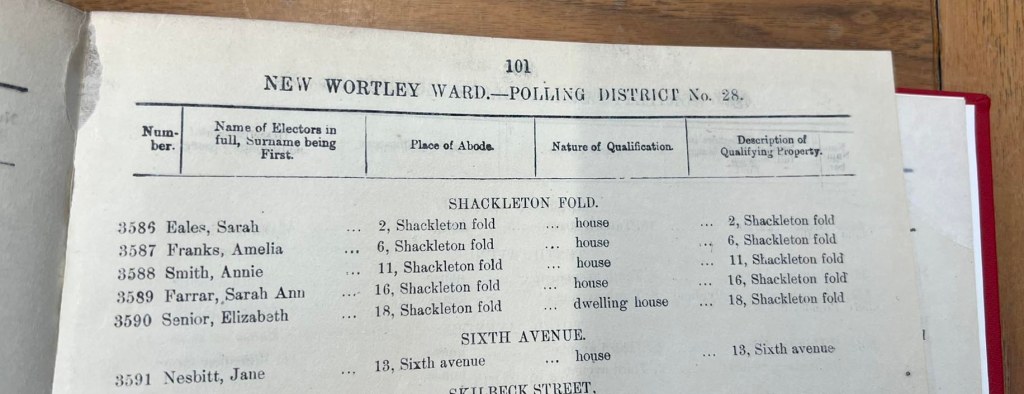
I’ve wanted to visit the Back to Backs Museum in Birmingham for several years, and finally last week had the opportunity to do it.

Maintained and operated by the National Trust, the museum is located at the junction of Hurst Street and Inge Street, about ten minutes’ walk from New Street Station. On the map below – surveyed in 1887 – I have outlined the exact location and extent of the museum.

The ‘museum’ is actual nineteenth century housing. Building commenced in 1802, and by 1831 what we see on the map was complete. The three houses fronting onto Inge Street were numbers 51, 52 and 53, although the numbering seems to have changed over time. Initially known as Wilmore’s Court, the courtyard is accessed via a passage between two of the houses, and would become known as ‘Inge Street, Court 15’

Map showing the location of the National Trust Back to Back Museum in Birmingham. The map was published 1890. It centres on the junction of Hurst Street and Inge Street, and the exact location and extent of the National Trust properties are indicated.
Ordnance Survey 25 inch Warwickshire XIV.5 Surveyed: 1887, Published: 1890
Reproduced with the permission of the National Library of Scotland
CLICK HERE for link to original on nls website

Back to back housing is a particular interest of mine. During the nineteenth and early twentieth centuries, all of my family lived in back to backs. The difference was that as the nineteenth century progressed, there had been an acceptance that the arrangement of back to backs around courtyards was unhealthy – particularly as such housing was generally of poor quality and included very unhygienic shared toilet facilities. Hence back to back housing in Leeds came to be built in rows of parallel streets, making a huge difference in terms of airflow and the health benefits flowing from that.

If you have ancestors living in urban areas, particularly in the rapidly-growing industrial towns like Leeds, Manchester, Liverpool and of course Birmingham, you can tell if they lived in back to back housing by looking at a large scale map – the 25 inch to a mile, like the one shown above is best. Using census records and, later, precise addresses on other documents, you may be able to work out the exact location on a map. Back to backs are identfiable by the line across the middle of what would otherwise appear to be one house. Each unit between the various lines was a separate dwelling. So you can see on the above map that almost every house in this part of Birmingham was a back to back. You can also see that some of the properties fronted on to the streets. These, being healthier and less malodorous, had correspondingly higher rents. However, far more of the properties were built in the courtyards: Birmingham had 20,000 of them.

The Public Health Act of 1875 allowed, but did not compel, municipal corporations to ban construction of new back to backs. By this time back to backs made up 45 per cent of Birmingham’s total housing stock, housing 170,000 people. Building new properties to replace them would have been a huge undertaking. It was not until 1909 that Birmingham actually prohibited the building of new back to backs. As new housing estates were built, the old housing was gradually demolished. The area around Inge Street and Hurst Street was designated for redevelopment in 1930, and gradually the courts were pulled down. However, Court 15 remained, and was inhabited right up until 1967. By the 1980s this little group of houses at the corner of Hurst Street and Inge Street was recognised as an important part of the social history of Birmingham – and indeed the country – and in 1988 the court was listed as a Grade II building.

It was not just the back-to-back formation and the cramped, unhealthy courtyard arrangements that made this type of housing problematic. It was also the number-of-family-members to number-of-rooms ratio; and this combined with the tendency for householders to take in lodgers, who often shared rooms or even beds with family members. Court 15 regularly housed as many as 60 people at one time. On top of this, there was the fact that the buildings themselves were quickly and cheaply built. There were no nationwide building regulations in 1831, and even when they did come into force in the final quarter of the nineteenth century, they did not apply retrospectively.

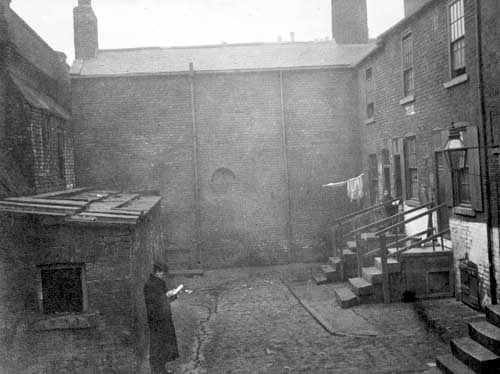
In fact back to backs are nothing unusual to me. My home town of Leeds still has about 19,000 such properties – about one third of the original number; and they are very popular with people looking for starter homes or on a lower income and preferring their own ‘house with a front door’ rather than a flat. I have been in many. The difference is that these 19,000 remaining back to backs are the better quality specimens. Some of them have small gardens, some have cellars and attics, and all are of sound construction. I wanted to understand the problems of the presumably 38,000 that were demolished. It was for this reason that I wanted to visit the National Trust Back to Backs ‘museum’ at Court 15.

Visitors to the site must pre-book on a guided tour. You can find out more and book tickets on the National Trust/ Birmingham Back to Backs website. The tours last about 90 minutes and you have to be able to climb (lots of!) very steep, cramped stairs with sharp bends and narrow, pointy treads. For people with limited mobility there is an alternative ground floor tour which lasts around 60 minutes and takes in the ground floors of each property.

My tour did not disappoint – and in fact lasted two full hours. Our guide had grown up in similar housing a few streets away in the 1940s and 1950s and had actually known one of the residents of Court 15. He was generous in answering questions about life in the courts and even had a photograph of his family with a huge damp patch on the wall behind. There was nothing ‘nostalgic’ about the presentation: these were terrible places, life was hard and the streets were dangerous. We learned about sleeping with a pole to crush the bugs, we saw the most awful damp attic and the cellar where sometimes children slept, and we learned about actual families who lived in these houses and the lodgers who sometimes shared their beds. It was exactly what I needed to know to help with my Shackleton’s Fold One Place Study as well as my nineteenth century ancestry in Leeds and – just a short distance from Court 15 – in 1850s Aston.

You can take as many photos as you want while walking around the court and houses; and I did. However, this is a National Trust property, and it wouldn’t be right for me to include any of them here other than these two views that you can see from the street. So instead, I recommend that you visit! If you have ancestry in Birmingham or Aston, or anywhere else where back to back housing was considered ‘the solution’ to the rapidly increasing populations of the nineteenth century, I’m sure you would learn something from a visit to the Birmingham Back to Backs.

A red brick building built in the 1830s. It is a corner unit. On the ground floor there is a shop with the sign 'National Trust'. Above the shop window the road sign is 'Hurst Street'.
Image: Janice Heppenstall 18 July 2025

Additional Source:
National Trust publication: Back to Backs Birmingham, 2004 available at the NT Birmingham Back to Backs reception.

Meeting the people of Shackleton’s Fold

In Leeds last month, I spent two days in the Local History department of the wonderful Leeds Central Library. I had a big task to complete, started last year, that will help me progress my Shackleton’s Fold One-Place-Study.

Comprising only nineteen properties, Shackleton’s Fold existed for less than a hundred years. It was built around the mid-1840s, precise year not yet known; and from 1895 until demolition circa 1938, was populated by quite a lot of my family members.

There are various strands to this One-Place-Study. First, the properties themselves – poor quality Back-to-Backs, or rather ‘Blind Backs’, since Shackleton’s Fold comprised just two rows of houses, each with the door and windows only on the front. The back of the house, instead of joining onto another identical property with the windows and doors on the other side, was simply a solid wall. No windows, no doors, and no other house. My study will include contextual information about Back-to-Backs, the industrial era working class housing for which Leeds is famous. Next, there are of course the people who lived there: the family members who lived in each of the houses during the time they stood. I’m interested in their stories, as well as what their lives reveal more generally about the lot of the labouring classes in this part of Leeds, during the second half of the nineteenth and first half of the twentieth centuries.

Before I can delve into their stories I need to find out who they are, and that’s what I was doing in the library: compiling a list of everyone on the Electoral Registers and Ward Lists. The objective was to use these to fill the gaps between the decennial censuses. This would enable a fine-tuning of the periods of residence for each household. If a named head of household was present for the 1861 and 1871 censuses but not the 1881, the registers could allow me to pinpoint the exact year they moved out.

Cataloguing the voters of just nineteen houses for around ninety-five years didn’t seem like such a big task, particularly since at the beginning of the period none of the residents had the vote. However, it has taken three full library days for me to do it – and even now I’ll need to return to check a few omissions and discrepancies.

A scene from a library. A red book with the title 'Leeds Register of Electors, West Division, 1896' and showing the catalogue number, is being held upright.  On the desk is a handwritten notebook with lists of dates, and a laptop.  Other desks and library users are visible beyond

Throughout the nineteenth century the population of the Borough of Leeds grew rapidly. In 1861 it was 311,197, rising to 503,493 in 1891 and by 1931 – the last Census for which Shackleton’s Fold was inhabited – the population stood at 646,119. This meant that the arrangement of the registers had to change. The sheer numbers of voters in these various registers meant they had to be divided into manageable chunks. Navigating these was a huge task. For example, a volume might bear the title ‘Borough of Leeds Ward Lists 1881 Part 2’, but with no indication as to which parts of Leeds were in Part 1, Part 2, etc; and this meant each ‘Part’ had to be browsed until the area needed was located. There was no guarantee that the following year would be similarly arranged, so the whole process had to be repeated.

Header page for electoral register, bearing the title 'Borough of Leeds Polling District Number 31, Township of Wortley, Number 3 Division'.  A note below indicates that the list that follows is of people entitled to vote in any Parliamentary election throughout 1870

If you’ve worked with Electoral Registers you’ll know that they are further divided into specific polling districts. The only way to work out which one you need is to look at the most likely ones until you find streets with names you recognise as local to your place of interest. Once you’ve done that you might think you’ve cracked it, and you’ll be able to whizz through the rest in no time. However, these polling districts also change. For example, in 1870, Shackleton’s Fold was in Polling District No. 31. In 1894 it was in West Division Polling District No. 28; changed to District No. 32 by 1899; then District 33, later to 39 and so on.

Front page of The Ward List for the Holbeck Ward, Township of Wortley, Number 1 Division, for the year 1876-77.  The beginning of a list of people is visible below the header

It gets worse! Electoral Registers list only those people entitled to vote in Parliamentary elections; and part of the appeal of a One-Place-Study for Shackleton’s Fold is that it existed throughout a period of great social change, including the move towards universal adult suffrage. During this time, some people were entitled to vote in Municipal but not Parliamentary Elections, and it’s interesting to chart the changes and know that behind each gain there was an important piece of legislation granting the vote to another group of people. This will definitely be covered in my One-Place-Study. However, since those entitled to vote only in Municipal elections could not be included in the Electoral Registers, there had to be another series of registers to list them. Therefore, alongside the Electoral Registers, there are also Ward Rolls, sometimes called Burgage Lists. Here, alongside the men included on the Electoral Registers, we find women and other men whose situation entitled them only to this local level of voting. Consequently there are (at least) two volumes of voters for every year. And guess what… the Polling Districts in the Ward Rolls have different names to those in the Electoral Registers! Shackleton’s Fold starts out in 1860 in ‘Holbeck Ward, Township of Wortley’. By 1874 it is the ‘Holbeck Ward Township of Wortley No. 3 Division’, and a couple of years later it’s No. 1 Division. By 1881 we have ‘Polling District No. 23 New Wortley Ward, Township of Wortley’, then ‘New Wortley Ward Polling District No 28’, and so on. By the 1920s even the township changes, to ‘Armley & Bramley’ and briefly to ‘Polling District MM Township of Leeds’.

As if that wasn’t difficult enough, it wasn’t until 1880 that voters were arranged by address. From this point forward, voters in Shackleton’s Fold are listed together, from number 1 to number 19. Before that year, locating each person involved line by line examination of every entry in the appropriate Polling District – once that had been found – and looking for the magic words ‘Shackleton’s Fold’, then making a note of the name of the person shown. Numbers of individual properties are not given, and since people often tended to move from house to house as their needs changed, there is no way of knowing for sure where each person resided other than at the decennial Census check-ins. Certainly from 1880 onwards the process was quicker, allowing for the speedy capturing of names and addresses with photographs of the relevant pages… at least, provided the Polling District hadn’t been renamed.

Top of page in Burgess List indicating that the named people who would follow were entitled to be enrolled as Burgesses, but not to be Registered as Parliamentary Electors

That said, for quite a few of the years, even after 1880, the women are listed in a separate part of the book, at the end of the entries for that polling district. Special mention must be made of the ‘Borough of Leeds Ward Lists 1872 Part 4’ in which, possibly because of a misunderstanding on the part of whoever compiled it into the one bound volume, locating the information involved examining every line on all 190 pages.

Extract from Burgess List showing the women who were entitled to vote in local elections.  These women were separated out from the male householders who, since 1867, had the right to vote also in Parliamentary elections
Women voters only. The men, who were now entitled to vote in Parliamentary as well as Municipal elections, were listed in the main part of the Ward Roll.

If you’ve ever worked with Electoral Registers, I’m sure some of the above will be familiar; but I suspect not so many of you will have been tracing the families of an entire street throughout a ninety-five year period! My advice to anyone planning on using Electoral Registers and Ward Rolls is: to allow far more time than you expect you’ll need; to understand the difference between the two, and their layout; and to make notes of the different Polling District names for each as you progress. This was a lesson hard learned for me, and explains why I now have a list of queries, and even a few volumes I now realise I missed.

That said, doing this is an essential foundation for everything that will follow. In addition to the decennial censuses from 1851 to 1921, the Electoral Registers and the Ward Rolls, I have information from The Borough of Leeds Poll Book. This was the first general election to be held after the passage of the Reform Act 1867, which enfranchised many male householders. Poll Books differed from Electoral Registers in that whereas the latter list who is entitled to vote, the former list not only who did actually vote, but also for whom they voted. It would not be until 1872 that the Secret Ballot was introduced, and so for many of our ancestors this is a once-only insight into their political affiliations. Other useful name-rich listings may include Directories and even addresses included on baptism and marriage registers. Luckily for me, for much of this period, all Church of England registers for Leeds are available on Ancestry.co.uk. – but not Roman Catholic or most Nonconformist registers.

These lists of people will form the basis of a database of every household, arranged alphabetically by surname. What I had really intended was simply to use these voter lists for fine-tuning periods of residence. I had anticipated that the real sources of information about the families would be the censuses. However, some residents lived in Shackleton’s Fold for only a very short period of time; and since all I have is the name of the head of household, there is no way of finding out more about them. The identity of a Thomas Brown, for example, who is listed on the Electoral Roll of 1871 and nowhere else – not even on the Census of that same year – will forever be unknown. However, Isaac Lord, also resident just briefly in 1870, turns out to have a sufficiently uncommon name for me to be able to track him down. Similarly, the juxtaposition of the head of household with his wife’s name on the Ward Lists may be sufficient to track a couple down via a marriage record.

My brain hadn’t flagged up that the lists themselves would also, with very little additional research required, witness the expansion of suffrage. It will be interesting to compare each increase of names with the relevant legislation. The lists even chart the final years of Shackleton’s Fold, helping me to narrow down the likely year of demolition. In 1938 only one resident remained, and by the following year he, too, was gone. Soon, Shackleton’s Fold would be no more.

If you want to follow progress on this One-Place-Study, you’ll find all blog posts and other information [here].

Housing the urban poor in 19th century England

“THE EDITUR OF THE TIMES PAPER
Sur, — May we beg and beseech your proteckshion and power. We are Sur, as it may be, livin in a Wilderniss, so far as the rest of London knows anything of us, or as the rich and great people care about. We live in muck and filth. We aint got no priviz, no dust bins, no drains, no water-splies, and no drain or suer in the hole place. The Suer Company, in Greek St., Soho Square, all great, rich and powerfool men, take no notice watsomdever of our complaints. The Stenche of a Gully-hole is disgustin. We all of us suffer, and numbers are ill, and if the Colera comes Lord help us.

Some gentlemans comed yesterday, and we thought they was comishioners from the Suer Company, but they was complaining of the noosance and stenche our lanes and corts was to them in New Oxforde Strect. They was much surprized to see the seller in No. 12, Carrier St., in our lane, where a child was dyin from fever, and would not believe that Sixty persons sleep in it every night. This here seller you couldent swing a cat in, and the rent is five shillings a week; but theare are greate many sich deare sellars. Sur, we hope you will let us have our complaints put into your hinfluenshall paper, and make these landlords of our houses and these comishioners (the friends we spose of the landlords) make our houses decent for Christions to live in. Preaye Sir com and see us, for we are living like piggs, and it aint faire we shoulde be so ill treted.

We are your respeckfull servents in Church Lane, Carrier St., and the other corts. Teusday, Juley 3, 1849.”

This letter was signed by fifty-four residents of the St Giles ‘rookery’ in London. Published on 5 July 1849 under the headline ‘A Sanitary Remonstrance‘.

***

The rapid expansion of our large industrial towns and cities started in the eighteenth century but was particularly so during the first half of the nineteenth, as increasing numbers of people migrated from rural areas and from Ireland. Between 1800-1850 the percentage of English citizens living in urban areas in the country as a whole increased from 30 to 50%, but in certain major industrial towns the growth was much greater. In Birmingham, between 1801 and 1851, the population increased from 71,000 to 233,000. In the same period Liverpool’s population grew from 82,000 to 376,000. In just one decade from 1821-31 Bradford’s population increased by 78%.

How on earth did these towns cope with housing and facilities for all these additional people? The simple answer is that they did not.

The thinking was that needs would be served by demand: employers would build factories, and speculative builders would build the housing needed for the incoming labourers. Of course the builders required a profit for their work, and the problem was that the workers were paid very little. Even the cheapest housing meant some workers were paying a quarter of a very meagre income on rent. By the end of the nineteenth century, nearly one third of the population would be considered ‘the very poor’.

There were several consequences. One was that purpose-built housing for the masses was of very poor quality, often built with just twenty or so years left on a land lease and deliberately built to last for just that length of time. Walls were the thickness of a single row of bricks, and the bricks themselves were often insufficently fired. Proper foundations were not dug out, meaning floor boards on the lower levels could be laid just a couple of inches above bare earth. In the Midlands and the North, back-to-backs became common. Each house had a party wall on three sides, with the door and windows only on the remaining side. Sometimes these were built in rows along parallel streets, but often they were arranged around courtyards, with the outer properties facing the street and the (cheaper) inner properties accessed via an alley or tunnel. Consequently, not only was there no possibility of air flow from one side of the house to the other, but the courtyard itself would have very little movement of air.

Room sizes were small, and despite the generally large family sizes, most purpose-built housing for the labouring classes had just two rooms: one up and one down, plus possibly an attic space. In the 1870s 43% of married women had 5 to 9 children; 18% had more than ten children. Hence as a matter of course, most individual family homes for the workers would be overcrowded.

As an alternative there was the option of repurposing existing housing. The large family homes built in the Georgian period for better-off families might now be sub-divided, with rooms on each floor let to different families. Repurposing in this way was always cheaper than purpose-built, but it did mean that the facilities and level of privacy originally intended for one family were now to be shared amongst several.

For the poorest of all, these already inadequate spaces were shared. Two, three or even more families would share small houses, designated rooms on a floor, or even one room.

Worst of all, the cellars of larger houses were rented out as dwellings – and even they might house more than one family. Some families even kept livestock in a pen alongside the family. There was, of course, no drainage. What’s more, the floors were bare earth and often they were below the water table, meaning they regularly flooded.

As the nineteenth century progressed and towns prospered, local authorities started to erect grand buildings as a testament to civic pride. Roads were widened to facilitate easier passage of large numbers of hansom cabs, and towns were redrawn to make way for railway lines and their stations. All of this required clearance of existing housing, and often the routes and locations selected specifically targetted the housing of the working classes. This was generally thought to be a good thing, since the housing was filthy, a health hazard and an eyesore. However, no new housing was built. Consquently, these grand developments meant worse overcrowding since more families had to cram into the buildings that remained. There were also raised rents, since unscrupulous landlords sought to take advantage of the scarcity of housing. In London, 120,000 people were displaced, and no new housing built to accomodate them.

Vast ‘rookeries‘, already unfit for human habitation, were the only areas available for the very poor. These were characterised by narrow alleyways and poorly-constructed multiple-storey dwellings crammed into whatever space was available. St Giles in London, where the signatories of the above letter to The Times lived, was a rookery. So too was the ‘Devil’s Acre’: the land on which Victoria Street in Westminster was built.

To this perfect storm of poor quality, inadequate housing, overcrowding and lack of ventilation, we must add one more fact of life: People need toilets.

The flushing toilet, or water closet, depends upon ready availability of water and a system of sewers, but it was not until the middle of the nineteenth century that these started to be installed as standard. Prior to that there were dry closets neutralised by earth or ashes; and cess pits. ‘Night soil’ would be collected by men whose job it was to take it to market gardens outside the towns, where it could be used as fertiliser. In some houses the cess pit was actually in the cellar, so that waste collected immediately below the floor boards of the ground floor dwelling rooms. Perhaps it was the rapid growth of towns and cities that meant these arrangements did not always go to plan, but we do know that collection of sewage and general waste was not always carried out. In one infamous rookery in Leeds called the Boot-and-Shoe Yard, no waste was collected for more than six months. When eventually this was remedied, over seventy cart loads were taken away. In any case, privies were shared between households – maybe as many as three hundred people, although the St Giles signatories claimed to have none at all: “We live in muck and filth. We aint got no priviz, no dust bins, no drains, no water-splies, and no drain or suer in the hole place.”

In 1842 serious concerns about the insanitary conditions in Leeds’s Boot-and-Shoe Yard led to the demolition of this rookery just off one of the main streets in the town. The 1841 census is therefore the only snapshot we have of the number and occupations of the residents. As can be seen from this extract, many of them were migrants from Ireland.

Extract from 1841 census showing entries for 12 individuals who were living in Leeds's Boot-and-Shoe Yard

Citation: 1841 Census of England and Wales. Original data: The National Archives. Source: Find My Past – the ‘I’ in the last column indicates those who were from Ireland

The popular view was that the muck and filfth was the fault of the residents, whose standards, lifestyle and morals were unacceptable.

It wasn’t until well into the second half of the nineteenth century that change gradually came. Prior to this there were no planning laws or building regulations. Gradually, local authorities were empowered to require builders to conform to certain minimum requirements, but many did not act on this because of the extra cost to the ratepayer. Increasingly it came to be understood that the health crisis and the housing crisis were two strands of the same issue, and permissive powers evolved into mandatory, but it would take the slum clearance and demolition programmes before finally these living conditions were consigned to the history books.

How can we make use of this information in our family history research?
Armed with this understanding of living conditions we can look for clues to learn more about the conditions in which our ancestors lived. Often, but not always, the worst conditions were occupied by immigrants. Here are some ideas:

Look for multiple households at one address in the census
In this extract from the 1901 census we see three households including 23 people living in one house. In fact this is only part of the return for number 5 Brick Lane: the rest are recorded on the following page. In total there are four households totalling 31 people. Three of the households have lodgers – a total of five lodgers altogether in the house.

Extract from 1901 census for 5 Brick Lane.  This shows 23 people from 3 households plus a lodger living at one address.  The rest of the inhabitants of this property are on the next page of the census and are not shown on this extract.

Citation: 1901 Census of England and Wales. Original data: The National Archives. Source: ancestry.co.uk

Look for families living in cellars
The houses in Liverpool’s Edmund Street had cellars, and as with many of the larger properties in Liverpool, these were let as separate dwellings. The main house at number 56 is a lodging house, with five lodgers, but another family is recorded in the cellar.

Extract from 1851 census showing a lodging house which also has a separate cellar let as a dwelling

Citation: 1851 Census of England and Wales. Original data: The National Archives. Source: ancestry.co.uk

Use the largest scale maps you can find to identify yards or courtyards, especially with back-to-backs
This small section of Lee’s Square is taken from an 1850 map of Leeds. Unfortunately the rest of the Square is on the next Ordnance Survey sheet. Thanks to the large scale of this map we can see individual properties. What we see is that most of the properties in Lee’s Square are back-to-backs. The property behind each abode has the door and windows looking out on to the street. The rents for those properties will be slightly higher. Although we can’t see from this map section, the privy will be inside the Square, also the water pump. This, added to the obvious lack of free-flowing circulation of air, will mean the inner properties are less healthy places to live than the outer.

Small extract from Ordnance Survey Town Plan of Leeds, Surveyed 1847, Published 1850.  The extract shows part of Lee's Square.  The markings on the buildings indicate that most of the properties are back-to-backs, and that Lee Square is a small courtyard formed of the inner facing properties.  The outer facing properties are on the surrounding roads.

Citation: Ordnance Survey Town Plan of Leeds, Surveyed 1847, published 1850. Reproduced with the permission of the National Library of Scotland. [Click here] for link to the full map.

Look for old photos of the addresses where your families lived
Ideally, you’ll be able to compare these with contemporary maps. The image below shows the same portion of Lee’s Square as you see on the map above. You can see the two sets of steps leading to the doors of two of the houses, and a cellar of some sort below. The photo is dated 1901 – fifty years after the map was surveyed and published, and the lean-to appears to have been added in the intervening years. The buildings on the southern side of the square seem to be lower and perhaps don’t have the substructure. This is of particular interest to me because my 2x great grandfather was living here in the 1890s. Thanks to a Coroner’s Report after his death I know that his house was above a stable, but it isn’t clear from this photo or its partner (looking east) where the dwellings above a stable would be.

Black and white photograph dated 1901 showing an old yard with two storey houses on each side and steps leading to three of the houses.  A man is standing outside a brick-built lean-to building on the left of the shot.  This may be a privy.

Citation: ‘Lee’s Square looking west, 1901’ Source: Leodis. [Click here] for link to image on Leodis website.

If you have ancestors who might be classed as ‘urban poor’ in the nineteenth century, I hope these ideas will help you.

All of this new research has been carried out as part of my One Place Study for Shackleton’s Fold.

I’m also developing a presentation on the subject of Housing the Urban Poor in 19th Century England. If this is of interest to you and your local or family history society, please take a look at my Public Speaking page, and follow the link at the bottom of that page to contact me.

***

Sources

David Olusoga & Melanie Backe-Hansen: A House Through Time, 2021. Picador, London

John Burnett: A Social History of Housing 1815-1970, 1978. David & Charles, Newton Abbot

Stanley D Chapman (Ed): The History of Working-Class Housing, 1971. David & Charles, Newton Abbot – this book has separate chapters on London, Glasgow, Leeds, Nottingham, Liverpool, Birmingham, South-East Lancashire/ Pennines, Ebbw Vale.

B R Mitchell and Phyllis Deane: Abstract of British Historical Statistics, 1962. Cambridge University Press.